Maximum Fire Danger Engulfs Portugal's Interior as Saharan Heat Arrives
Seventeen municipalities across Portugal's northern and central territories entered maximum wildfire danger today as temperatures climb toward 37°C, grounding aircraft normally deployed for rescue operations and forcing strict enforcement of outdoor activity bans. The combination of severe heat, drought-stressed forests, and stretched emergency resources has created conditions that authorities describe as a critical turning point in the nation's fire season. For residents in affected zones, compliance with activity restrictions is no longer advisory—it has become a legal and practical necessity.
Why This Matters
• Immediate action required: Seventeen municipalities across eight districts face maximum fire danger through Wednesday, with hard outdoor restrictions now enforceable by local authorities and backed by potential fines.
• Geographic concentration: Risk zones form a band across Vila Real, Bragança, Viseu, Guarda, Coimbra, Castelo Branco, Faro, and Portalegre, districts that have historically accumulated the largest cumulative fire damage and possess the fewest firefighting resources per square kilometer.
• Dual emergency strain: Air Force rescue helicopters normally available for fire reconnaissance and water-dropping are committed to maritime medical evacuations, reducing inland emergency response capacity at a critical moment.
• Escalating pattern: The burned area in 2025 through August has already surged 259% above the decade average, suggesting climate-driven fire behavior is fundamentally changing how rapidly even minor ignitions spread.
The African Heat System and What It Means
A high-pressure dome anchored over the Iberian Peninsula is pulling a mass of tropical air northward from the Sahara. This collision between warm interior air and a low-pressure system positioned west of mainland Portugal has created the meteorological conditions that the Portugal Institute of Sea and Atmosphere (IPMA) identifies as critical to understanding today's fire environment.
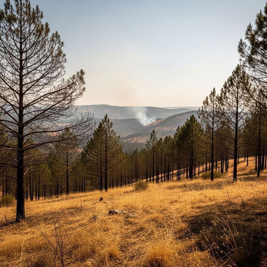
Temperatures will swing dramatically by geography. Coastal western zones like Aveiro will remain relatively moderate at around 22°C, while interior plains around Évora are forecast to reach 37°C—nearly 15 degrees higher despite being in the same country. More troubling than daytime peaks is the fact that nighttime temperatures will barely drop below 20°C across most interior regions, eliminating the natural cooling window when vegetation might absorb moisture from the air or when fire behavior typically slows. Fire services depend on these overnight cool periods to consolidate containment lines and rotate crews; today that respite simply will not arrive.
Relative humidity—the critical variable determining fire spread—will plummet to 20–30% in interior zones. This metric matters far more than absolute temperature to firefighters. At these humidity levels, a fire that might normally advance 10 meters per hour can double or triple its rate of spread. Vegetation that has absorbed months of below-average rainfall exists in a state of pre-ignition desiccation, ready to burn with surprising speed and intensity the moment a spark lands.
The Alert System and What Residents Face
The Portugal Institute of Sea and Atmosphere operates on a four-level alert hierarchy. Orange represents the second-highest warning tier—essentially signaling that meteorological conditions are outright dangerous and demand immediate public attention and preparation. Bragança, Guarda, and Vila Real have received orange alerts valid through 18:00 today, then downgrade to yellow (the third level) through 18:00 Wednesday.
Eight additional districts—Viseu, Évora, Porto, Viana do Castelo, Coimbra, Castelo Branco, Braga, and Portalegre—are operating under yellow alerts through the same period. Yellow warns of risk without the same immediate severity. The downgrade from orange to yellow Wednesday afternoon will likely be the trigger for some restrictions to ease, though authorities have not yet announced which prohibitions will be lifted or when outdoor activity will resume.
For residents in orange zones, the next 24 hours represent a do-not-relax period. Authorities will be monitoring atmospheric conditions in real time and can escalate alerts upward, or maintain them longer than originally forecast, if fire conditions prove more severe than predicted.
The Seventeen Municipalities at Maximum Danger
These territories were selected not randomly but by algorithm. The IPMA fire danger calculator ingests real-time data—air temperature, relative humidity, wind speed, and precipitation recorded in the previous 24 hours—and applies a mechanistic model to output one of five danger levels. Today's atmospheric inputs guaranteed maximum or very high ratings across most interior zones.
Vila Real district contributes Montalegre and Chaves, both perched in granite highlands with dense pine plantations that burn with particular ferocity. Bragança district carries the heaviest concentration: Vinhais, Bragança proper, Macedo de Cavaleiros, Vimioso, Miranda do Douro, and Mogadouro—a contiguous band across the northeastern plateau bordering Spain. This region has historically proven one of the most fire-prone in the country.
Guarda district adds Figueira de Castelo Rodrigo, Pinhel, and Almeida—three border communities where rugged topography actually accelerates fire behavior. As flame moves uphill, it encounters drier vegetation and encounters less wind shear, creating what firefighters term "plume-dominated" spread where the fire's own convective updraft pulls flame toward unburned fuel.
Viseu flags three interior municipalities: Armamar, Moimenta da Beira, and Tabuaço, all positioned where the Dão River basin's terrain amplifies fire's ability to advance. Coimbra contributes a single municipality, Pampilhosa da Serra, a remote interior zone with limited road access for evacuation or fire crew positioning. Castelo Branco adds Oleiros, Portalegre includes affected municipalities in its interior zones, and Faro includes Tavira in the far south.
Beyond these 17 maximum-danger zones, dozens of additional municipalities in these same districts plus Leiria, Beja, Évora, Santarém, and other regions remain at "very high" danger—the second-highest classification. The North region alone has historically recorded 18,300 hectares burned annually with more than 2,400 individual fire incidents. The cumulative statistics are sobering: Guarda district has burned 454,850 hectares since 2010, with Castelo Branco at 360,565 hectares and Viseu at 334,348 hectares. These numbers represent entire regional economies damaged, forests decades away from recovery, and repeated evacuations.
What Is Now Prohibited in Red-Zone Municipalities
When the National Authority for Emergency and Civil Protection (ANEPC) designates a municipality at maximum or very high danger, a rigid set of prohibitions takes effect immediately. Violations are enforceable by municipal authorities and backed by fines ranging from €100 to €3,000 for individuals and €5,000 to €15,000 for organizations, depending on severity. Criminal liability attaches if prohibited behavior directly causes a fire.
Completely banned starting today in affected municipalities:
Outdoor cooking in any form. This includes barbecues, campfires for recreation or gatherings, and outdoor grilling at picnics or family events—even in designated recreational areas within high-risk zones. Some residents assume that portable grills or designated park grills are exempt; they are not. Gas-fueled and charcoal-fueled cooking devices both pose ignition risk through uncontrolled flame exposure, hot ash dispersal, and operator error.
Powered brush-cutting equipment. Moto-scythes, brush-cutters, and debris shredders are prohibited unless they use non-metal cutting heads—a specification that virtually no commercial equipment meets. Chainsaws, angle-grinders, and any handheld tool generating sparks through friction or blade contact are forbidden outright.
Agricultural burning and land clearing. Residents cannot burn their own property, even if they own the land, without prior written authorization recorded in the ANEPC's online "Queimas e Queimadas" system (burnings.proteccaocivil.pt). Authorization is rarely granted during orange or red alerts. Many rural landowners discover too late that they cannot legally dispose of brush accumulation during peak fire season; legitimate disposal requires completion by late spring or hiring professional services.
Smoking, open flames, or any fire in forests, shrubland, or agricultural land. This extends to ceremonial or recreational fires, including traditional bonfire gatherings.
Heavy machinery operation without spark suppression. Tractors, excavators, compressors, and other equipment must be equipped with a functioning fire extinguisher, a spark arrestor on the engine exhaust, and a flame-trap device on the muffler. Many rural operators own equipment predating these requirements and have not retrofitted. Operating such machinery in a maximum-danger zone today represents a criminal exposure.
Drone flights and ultralight aircraft over Priority Prevention and Safety Areas (APPS)—designations that encompass most forested zones in high-risk municipalities. This prohibition also applies to organized hiking groups, outdoor weddings, sporting events, and cultural festivals that concentrate people in APPS areas, even if the individual activities themselves would normally be legal.
Household maintenance requirements are simultaneously binding. Residents must maintain a 50-meter perimeter around homes entirely free of burnable material: firewood stacks, dry brush, fallen leaves, low-hanging tree branches, and wooden structures crammed with combustibles. Gutters and roof valleys must be cleared of leaves and small twigs. These are not recommendations; they are legal fire-prevention obligations. Failure to maintain them can result in liability if a fire approaches and finds abundant fuel providing acceleration.
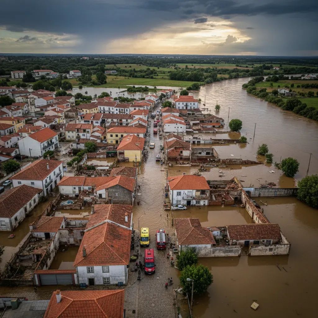
A Weekend Fire Demonstrates Real Escalation
On Saturday, June 21, a wildfire erupted in Beja district at Monte dos Doutores, a cork-oak woodland typical of southern interior Portugal's montado ecosystems. The blaze began at 13:18 and immediately triggered ANEPC's "significant incident" classification—a designation reserved for fires requiring multi-agency response and continuous monitoring.
No homes stood in immediate proximity to the flame, but a nearby river beach popular on summer weekends posed secondary risk if the fire spread laterally toward the water. Evacuation protocols activated as a precaution. By 22:00 the same evening—a nine-hour operational engagement—61 firefighters supported by 21 vehicles brought the fire under control and began mop-up operations (technically called "rescaldo").
The incident was contained before becoming regional news, but it illustrates the razor margins at play. That same fire, occurring 12 hours later during peak afternoon heating and with stronger atmospheric winds, could easily have spread into a multi-municipality disaster requiring regional evacuation and overwhelming local resources. The difference between a managed incident and a catastrophe is often measured in hours, wind direction, and vegetation density—factors that leave no room for complacency.
Air Force Stretched Thin by Triple Maritime Rescue
While land crews managed the Beja fire, Portugal's Air Force faced simultaneous strain through a sequence of urgent medical evacuations at sea. Between June 19 and June 21, the Portugal Air Force executed three critical rescue missions in less than 24 hours, illustrating how compressed emergency response capacity becomes when crises cluster in time.
On the evening of June 19, an EH-101 Merlin helicopter from Squadron 752 at Base Aérea Nº 4 in the Azores launched toward the cargo vessel Sigma Triumph, positioned approximately 950 kilometers northeast of Terceira Island. A 26-year-old crew member required immediate medical evacuation for an undisclosed condition. The extreme distance forced simultaneous deployment of a C-295M transport aircraft from Squadron 502, which served as a safety relay and communications node to coordinate recovery.
Later on June 21, at 09:30, a second emergency request arrived from the cargo vessel Monte Brasil, positioned roughly 300 kilometers offshore. A 40-year-old sailor required urgent extraction. The helicopter, diverted to this rescue location, successfully recovered the patient.
At 13:55 on June 21, while operations from the second mission were concluding, a third emergency request arrived. A 27-year-old sailor aboard Kenya B, positioned roughly 420 kilometers offshore, needed urgent extraction. The Merlin immediately diverted to the third rescue location with the C-295M again providing overhead coverage.
Across the three operations, the Merlin accumulated 9.5 hours of flight time; the C-295M logged approximately 5 hours. All three patients received hospitalization in the Azores. The operational tempo reveals a structural tension in Portugal's emergency capacity: aircraft committed to maritime rescue are unavailable for inland fire reconnaissance, personnel transport, or water-dropping operations—precisely the missions that become most critical during maximum fire danger.
The Decade's Troubling Pattern: Fewer Fires, Faster Spread
Portuguese fire statistics reveal a counterintuitive and alarming trend. The number of reported fires has declined markedly over the past decade, yet the area burned in individual fire seasons has become unpredictable and, in some years, catastrophic—suggesting that climate change is altering fire behavior fundamentally.
2023 recorded 7,523 fires—the second-lowest count since 2013—but burned 34,509 hectares, a moderate outcome for the year. 2024 improved even further on fire counts, dropping to just 6,255 incidents, the lowest on record for the period. Yet 137,651 hectares burned—the third-highest area since 2014. The disconnect is stark: one-third fewer fires, but substantially more territory consumed.
2025 data through August (still incomplete but alarming) shows 254,296 hectares burned on 7,042 fires—a 259% increase in burned area compared to the decade average. This trajectory suggests that atmospheric change is altering fire behavior at a fundamental level. Hotter, drier conditions combined with multi-year cumulative drought stress on vegetation mean that even modest ignitions now exploit fuel that burns with unusual intensity and speed.
Post-incident investigations reveal that 34% of fires are deliberate (incendiarism), while 32% stem from authorized agricultural burning and debris clearing—often conducted without proper permits or during unsafe conditions. The remaining third of incidents trace to equipment use, transportation, and recreational activity. The implication is clear: human behavior remains the source of most ignitions, but once started, fires now spread at rates that overwhelm historical response protocols.
Individual Behavior as the Primary Defense
Portugal's National Plan for Integrated Rural Fire Management (PNGIFR), running through 2030, emphasizes reducing human-caused ignitions, improving fuel management in forests, and strengthening firefighting logistics. Results have been mixed. Ignition reduction campaigns appear to be working; fewer fires are starting. But climate-driven fuel drying and behavioral change—fires that do ignite spread faster and burn larger patches—suggest that prevention alone cannot solve the problem.
For residents, the calculus is straightforward: individual compliance is the first and most cost-effective line of defense. Most rural fires are human-caused, and most human causes are preventable through simple behavioral discipline. Not burning during high-risk periods. Not operating chainsaws or brush-cutters carelessly. Not abandoning barbecues unattended. Not littering cigarettes or metal debris that might spark under vehicle wheels. Not conducting unauthorized land clearing during maximum-danger forecasts.
These behaviors, multiplied across thousands of households, determine whether a heat wave passes with managed incidents or becomes a catastrophe. Authorities coordinate closely, resources are positioned strategically, and protocols are rehearsed—but firefighting services cannot overcome the physics of fire spread when vegetation is desiccated, atmospheric conditions are extreme, and the ignition source is fed by careless human action.
The Week Ahead and the Larger Season
Conditions are expected to ease gradually after Wednesday. IPMA and ANEPC have not yet announced when outdoor restrictions will be lifted, as that depends on wind-pattern evolution, humidity recovery, and any chance of precipitation. Residents in maximum-danger zones should monitor daily updates; municipal websites post alerts and restriction changes regularly.
The official Portuguese fire season extends from May through October, but July and August—when the landscape is fully desiccated and Mediterranean air masses dominate—historically produce the nation's largest fires. June marks only the transition into the most dangerous months. This current heat surge is an early reminder that peak danger remains ahead.
The underlying vulnerabilities persist regardless of this week's outcome: drought-stressed forests, accumulated dead fuel from decades of fire suppression and incomplete forest management, and climate-driven intensification of fire behavior. Authorities, forestry services, and emergency responders are coordinating closely—but they cannot fight fires alone. Public compliance with outdoor-activity bans, household fuel management, and conscious restraint from unauthorized burning remain the most reliable and cost-effective tools available. As northern interiors dry and African air masses drift northward, that collective vigilance becomes the hinge upon which the difference between a manageable fire season and a catastrophic one turns.