
A Sharp Cold Snap Disrupts Northern and Central Portugal This Week
Portugal's Instituto Português do Mar e da Atmosfera (IPMA) has issued a succession of yellow-level weather alerts affecting multiple districts, signaling that Tuesday will deliver a day of genuine disruption across highland transport corridors, fishing grounds, and rural communities. The weather system driving this pattern—a cold front coupled with Atlantic moisture—will deliver scattered to moderate rainfall, accumulating snow above 800 meters in mountain terrain, frost formation in interior lowlands, and coastal swells reaching dangerous heights for small maritime operations. For residents across the North, Centre, and South, this represents a meaningful weather event requiring practical precautions rather than a catastrophic scenario.
Why This Matters:
• Mountain passages face potential closures—Serra da Estrela, Serra da Lousã, and associated routes may see restricted access if snow accumulation exceeds 10 cm above 1,200-meter elevations
• Coastal wave heights of 4–4.5 meters disrupt fishing schedules and ferry operations until early afternoon across multiple districts
• Overnight frost hazard in interior North and Centre creates slippery agricultural roads and threatens frost-sensitive spring plantings from Guarda to Bragança
How the Cold Front Will Move Across Portugal
Tuesday's weather pattern emerges from a textbook Atlantic scenario: cold polar air sliding southward across the North Atlantic, intersecting with moisture-laden systems tracking eastward from open ocean. As this atmospheric collision occurs over Portugal's exposed western face, orographic lifting forces air upward along highland terrain, cooling it until water vapor condenses into precipitation. At higher elevations, the precipitate falls as snow; at lower altitudes, it arrives as rain mixed with occasional hail and thunder.
The IPMA's forecast architecture divides the country geographically because altitude and latitude determine precipitation form. Northern and central highlands above 800 to 1,000 meters will accumulate snow through the late afternoon hours. The snow line itself will rise gradually—reaching 1,400 to 1,600 meters by evening as the cold air mass moderates slightly—meaning lower passes open before alpine routes. Southern regions and the coastal lowlands escape snow entirely, instead receiving showers occasionally punctuated by hail and lightning activity.
Wind conditions enhance the disruption. Winds will blow from the north at light-to-moderate speeds overall, but certain zones experience temporary intensification. Coastal regions south of Cabo Mondego—essentially Portugal's western seaboard from central Estremadura southward—and exposed mountain passages in the Centre and South will encounter gusts reaching 60 km/h through mid-afternoon. This means reduced visibility during rainfall, vehicle-handling challenges for light vehicles traversing highland roads, and operational constraints for construction and outdoor commerce in exposed zones.
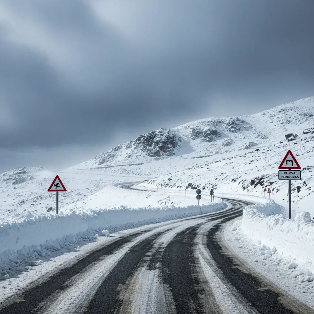
Which Mountain Roads Face Real Closure Risk
When the IPMA warns of "snow accumulation above 1,200 to 1,400 meters," residents often miss the practical geography. Portugal's highest and most problematic passages cluster in a band stretching from Serra da Lousã (Covilhã area) through Serra da Estrela (touching Guarda and Castelo Branco) to Serra do Açor (Covilhã and Idanha-a-Nova region). These aren't novelty peaks; they're working mountain passes threading north-south commerce through Portugal's interior, connecting landlocked Beira Interior regions to coastal markets and the Atlantic highway network.
Serra da Estrela specifically experiences its peak snow season in March rather than December or January—a counterintuitive but well-documented pattern driven by March's lingering cold and Atlantic frontal activity. Historical records document 430 millimeters of snow accumulation across the full March month in heavy years, with individual events routinely depositing 5 to 15 centimeters in 24 hours. Tower (Torre), the massif's highest point at 1,993 meters, sits almost permanently in the snow-line zone during March; the lower Piornos-Lagoa Comprida saddle at 1,300 meters represents the unpredictable threshold where conditions shift from negotiable to impassable within hours.
Early this March already tested this infrastructure. Road authorities (the Instituto da Mobilidade e dos Transportes Terrestres, or IMTT) closed sections of the Serra between these key points due to snow intensity, reopening only after salt application and thermal recovery. Tuesday's event follows an identical atmospheric template—cold polar air, orographic forcing, moisture delivery—suggesting similar outcomes remain plausible.
Beyond Serra da Estrela, the IPMA has designated alerts for Guarda, Castelo Branco, Viseu, Vila Real, and Bragança districts. This geographic spread reflects the scale of Portugal's interior mountain network. Viseu and Vila Real encompass the Serra do Marão and portions of Serra de Montemuro; Bragança includes passages through the Parque Nacional Peneda-Gerês reaching 1,500+ meter elevations where snow regularly blocks access in March. Even Guarda—sitting in a river valley rather than atop mountains—experiences frost and ice formation on surrounding rural roads serving agricultural zones and connecting smaller towns.
Interior Frost: The Overnight Hazard for Rural Communities
The IPMA forecast includes explicit warning of "ice formation in interior North and Centre overnight." This phrasing deserves unpacking for non-rural residents. Frost formation occurs when clear skies permit nighttime radiational cooling—the ground loses heat directly to space without cloud insulation, and surface temperatures drop below 0°C. This process typically intensifies between 4 AM and sunrise when atmospheric temperatures reach their daily minimum.
The rural road networks serving agricultural communities—especially in Guarda, Viseu, Vila Real, and Bragança districts—show characteristic vulnerability: hairpin turns on valley approaches where water runoff freezes before dawn traffic clears the ice; drainage channels transecting roads where groundwater seeps onto pavement surfaces and freezes; bridges over waterways freezing before adjacent road sections because air flows underneath, accelerating cooling. Residents in these zones navigate this reality annually, but today's forecast combines overnight frost with preceding precipitation, creating compounded hazard. A rain-slick road freezes faster and more extensively than an initially dry surface encountering frost.
Agricultural producers face parallel concerns. Early spring plantings of vines, fruit trees, and market-garden transplants—sectors critical to rural economies in interior North and Centre—experience mortality from frost exposure. Sensitive crops require protective measures: overhead irrigation systems that generate insulating ice layers (counterintuitive but effective), frost blankets positioned before nightfall, or wind machines that mix warmer air from upper atmosphere downward. The frost window extends roughly 11 PM through 8 AM, with maximum risk between 4 AM and sunrise. Passive protection using heavy mulch and row covers costs minimal investment but demands advance staging.
Atlantic Swells and Maritime Operations
Portugal's fishing economy hinges on precise understanding of state-of-sea forecasts. The IPMA predicts northwest waves reaching 4 to 4.5 meters Tuesday, with warning expiration times staggered by district: Aveiro, Porto, and Braga until 6 AM; Coimbra through 9 AM; Leiria until noon; Lisbon until 1 PM; and Faro, Beja, Setúbal until 3 PM. This geographical pattern reflects how Atlantic swells diminish as they propagate southward and lose energy to friction with continental slope bathymetry.
Swell heights of 4 to 4.5 meters translate to roughly 13 to 15 feet—significant enough to restrict smaller vessels. Artisanal fishing operations targeting species in nearer waters typically shelter in protected anchorages rather than venture into such conditions; fuel expenditure climbing seaward against choppy conditions, combined with reduced catch probabilities and increased equipment stress, makes the decision economic rather than merely cautious. Ferry services connecting Portugal to adjacent regions experience delays and potential cancellations if wave action triggers maritime safety protocols.
For context, this Tuesday's forecast represents marked improvement over conditions earlier in March. On March 6, the IPMA elevated coastal alerts to orange level—the second-highest warning tier—forecasting maximum wave heights reaching 11 meters along Lisbon and Leiria coasts. That event occurred between 9 AM and 6 PM, generating structural damage to exposed coastal facilities, restricting beach access across metropolitan Lisbon's littoral, and compelling ferry cancellations. Those 11-meter waves represent extreme conditions; Tuesday's 4-to-4.5-meter swells, while operationally disruptive, feel almost routine in historical March context. Yet they still compress the profitable operational window for maritime industries.
Temperature Collapse: A Week Without Spring Warmth
The thermometer tells an unambiguous story. Minimum temperatures Tuesday will range from 1°C in Guarda to 10°C in Faro—a geographic divide reflecting interior continental exposure versus southern Mediterranean moderation. Maximum temperatures will climb only to 9°C in Guarda, 13°C in Viseu, and 17°C in Braga. These represent measurable withdrawal from recent days' warming trajectory.
Residents accustomed to late-winter patterns where each March week delivers slightly higher maximum temperatures will notice this reversal acutely. Central heating systems assumed dormant or minimal-use status suddenly require reactivation. Families budgeting heating fuel must recalibrate consumption expectations. Commercial sectors sensitive to heating demand—hospitality, retail, healthcare facilities—experience increased operational costs.
Beyond immediate comfort implications, this temperature collapse signals broader atmospheric dynamics. The IPMA's weekly bulletin projects temperatures remaining below historical March averages through the following Monday and Tuesday. Expected highs cluster between 6°C and 16°C; lows range 1°C to 9°C. This represents compression of seasonal warming patterns—March typically features steadily ascending temperature curves as the vernal equinox passes and solar elevation increases. This year's early-March pattern stalls that progression abruptly.
Showers, Hail, and Thunderstorm Risk in Centre and South
The rain-producing mechanism differs geographically. Northern coastal lowlands and western plains receive lighter precipitation; the Centre, South, and northeastern Trás-os-Montes regions experience intensifying showers through late afternoon. This geographic concentration reflects atmospheric dynamics: terrain funnels moisture-laden winds upward, forcing ascent and precipitation release.
Showers will occasionally arrive as hail—frozen precipitation forming in vigorous updrafts—and may be accompanied by thunder and lightning activity, particularly in the South. These phenomena emerge from single-cell thunderstorms that develop when cold air aloft meets warmer, moisture-rich air at lower levels. The trigger mechanism intensifies through afternoon as solar heating of exposed ground enhances convection.
Wind direction reinforces this pattern. North-quadrant winds—flowing from the Arctic and northern Europe—drive moisture across Portugal's interior before encountering elevated terrain in Centre and South. Southern regions with less topographic obstruction experience lighter overall precipitation but localized convective enhancement where terrain forces orographic lifting. This explains the forecast's emphasis on Centre and South intensity, contrasting with comparatively moderate precipitation further north.
Residents in affected zones should anticipate temporary visibility reduction during peak rainfall hours and expect hail accumulations (typically 1-3 mm in diameter) that briefly blanket roads before melting. Outdoor commerce—roadside construction, harvest operations—should plan workflow adjustments. Vehicle operators should reduce speed; aquaplaning risk increases with hail-generated surface water.
Early March: Spring Delayed but Warming Ahead
The IPMA's seasonal outlook for March-May projects above-average temperatures overall for Portugal and the Azores, yet this apparent contradiction with Tuesday's cold snap reflects atmospheric transition dynamics. Early March delivers a temporary incursion of Arctic air; late March rebounds toward above-average warmth. The net monthly temperature signal tilts warm, but residents experiencing this week's frost and snow should understand: spring's arrival stalls temporarily before rebounding.
Precipitation forecasting at seasonal timescales shows normal totals expected for the three-month March-through-May window. This equilibrium emerges from redistribution: early March's unusual dryness (Lisbon recorded merely 6.5 millimeters against a historical average of 53 millimeters for the full month) will likely compress later, creating wet spells restoring seasonal balance. April typically delivers heightened precipitation, suggesting compensatory rainfall patterns lie ahead.
Historical analysis of March weather in Portugal documents a persistent vulnerability window. The past three decades reveal a warming trend of roughly 1.2°C in southern Portugal's March temperatures, yet individual years deviate substantially. This early-March pattern—temperatures below average, precipitation deficit—occurs regularly within this broader warming trajectory. It represents a temporary obstruction rather than climate reversal.
Practical Guidance for Tuesday and Beyond
Mountain travelers and transport operators should verify road status before attempting highland passages. The IPMA and IMTT do not issue closure notices in advance; authorities decide in real-time based on snow depth and road surface conditions. This unpredictability demands flexibility: a planned journey to Guarda or mountain passes may require rerouting or postponement with minimal warning. Commercial transport firms routing goods through Serra passages should build contingency time into schedules and actively monitor IMTT alerts for real-time closures.
Coastal fishing and maritime operations should respect the wave warnings. Ferry services should confirm schedules before departing; some operators may adjust timing or suspend service depending on swell height. Recreational water activities warrant postponement until afternoon when warning expiration times suggest improving conditions and swell heights declining.
Urban residents should ensure home heating systems function properly—today's indoor comfort depends on reliable equipment. Exposed pipes in unheated spaces deserve minor insulation using newspaper wrapping or commercial foam sleeves to prevent freezing. Vehicle fuel should include anti-freeze treatment if traveling into highland or interior zones overnight. Parents should check school closure announcements Tuesday morning for highland-region institutions; the IMTT may close passes, stranding school buses on wrong sides of closures.
Agricultural producers in northern and central interior zones should activate frost-protection protocols before nightfall. Sensitive crops—early-season vineyard buds, fruit tree blossoms, market-garden transplants—warrant overhead irrigation systems or frost blankets. The frost window extends from approximately 11 PM through 8 AM, with most severe cold between 4 AM and sunrise.
Looking Beyond Tuesday
By Wednesday morning, atmospheric conditions should begin stabilizing. The cold front passes; wind patterns shift. Temperatures will remain below average through Thursday and Friday, but precipitation probability diminishes and frost risk concentrates exclusively in interior zones. The weekend outlook, pending Wednesday forecast updates, suggests gradual warming as a secondary high-pressure system establishes itself over the Atlantic.
Residents should monitor IPMA updates through evening Tuesday for road closure announcements and warning extensions. The institute typically posts revisions by 3 PM for afternoon phenomena and by 9 PM for overnight developments. The mobile app Meteo@IPMA delivers push notifications on alert changes—particularly useful for residents in affected districts needing real-time information for commuting or operational decisions.
By the weekend, Portugal emerges from this temporary Arctic intrusion into more stable conditions reflecting the month's broader warming trend. This week's cold snap, while disrupting schedules and requiring precautions, represents the seasonal volatility characteristic of March—a month perched between winter's lingering influence and spring's advancing warmth.


