
Lisbon’s commuters, mountain hikers in the Serra da Estrela and Algarve beach-goers are all facing the same weekend headline: unstable skies, colder air and disruptive downpours. A vigorous Atlantic front linked to Depressão Ingrid will cross the country between Saturday and Sunday, dragging in thunderstorms, snow above 600 m and a persistent westerly wind.
Snapshot for the time-pressed
• Strongest rain during Saturday morning in the North and Centre, shifting south after lunch.
• Snow likely above 600/800 m; brief drops to 400 m in higher valleys overnight.
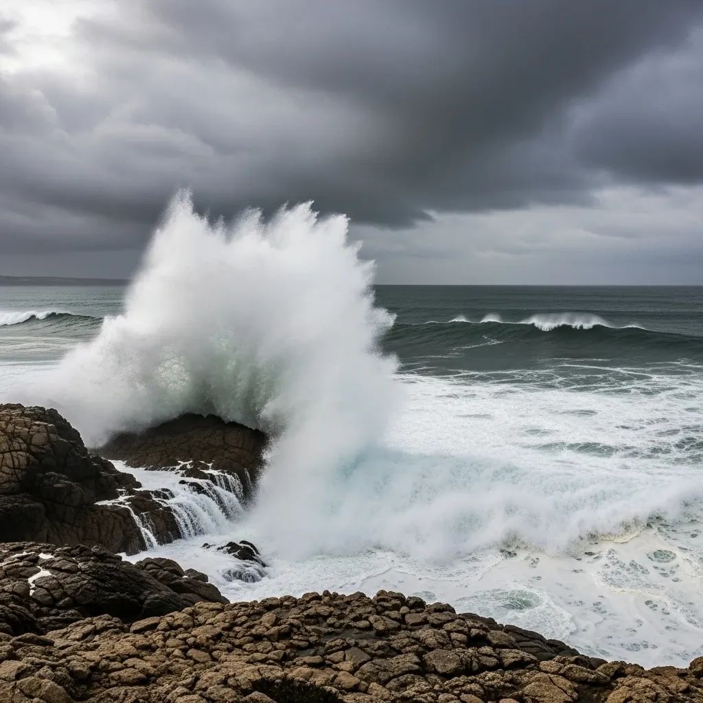
• Coastal swell surpassing 7 m places western beaches under an orange to red sea-state alert.
• Moderate but gusty westerlies at 40 km/h inland, 75 km/h on exposed headlands.
• Temperatures edging below seasonal norms – daytime highs of 9 °C inland North, 13–15 °C around Lisbon.
Weather story region by region
Greater Lisbon & Tagus Valley
Confidence is growing that the capital will dodge the worst of Ingrid’s punch, yet even here intermittent rain bands will slow traffic on the 2ª Circular and Vasco da Gama bridge. Saturday tops out at 13 °C, slipping to 10 °C after sunset. Sunday starts grey, brightens briefly mid-afternoon, but keeps a drizzle in the forecast. Moisture-laden air and wind gusts of 60 km/h will amplify the chill factor for anyone waiting at the bus stop.
Northern districts
From Viana do Castelo down to Porto and inland to Bragança, residents should brace for frequent aguaceiros, local hail and rumbling trovoada. Snow line hovers near 700 m; Peneda-Gerês and the Montesinho plateau can expect a fresh white coating. Thermometers fluctuate between 1 °C at dawn and 9 °C mid-day. Road authorities have pre-positioned gritting teams on the A24 and IC5.
Central mountains & coast
Aveiro, Coimbra and especially the Serra da Estrela enter a 48-hour window of wintry danger. Blizzard-style bursts may drop 20–30 cm of snow above 800 m. Sea-level towns still get soaked; traditional student reunions in Coimbra might require umbrellas rather than scarves as peaks of 12 °C combine with sharp showers.
Alentejo & Algarve
Saturday launches with thunderstorms rolling inland from Sines toward Évora and Beja. The storm line weakens on Sunday, leaving patchy sunshine and 17 °C in Faro, but heavier cells regroup late Monday. Strong surf and rip currents prompt lifeguards to discourage winter surfing beyond sheltered bays.
Madeira & the Azores
Out in the Atlantic, the frontal tail sweeps across the Azores first, keeping Ponta Delgada locked under dense cloud, 17 °C highs and showers through Wednesday. Madeira escapes the snow element but still sees bursts of heavy rain and 70 km/h gusts along the north coast.
How it may affect your weekend plans
Road travel – Slick tarmac, fallen branches and low visibility could extend Lisbon–Porto drive times by an hour. Chains may become mandatory on EN339 in the Serra da Estrela.Rail – Planned works will halt Cascais line services between São Pedro do Estoril and Cascais from 08:00 Sunday; check CP’s app for buses. Storm-driven debris occasionally blocks Minho line tracks during similar setups.Public transport – Lisbon’s Carris notes past flooding prone to close Avenida da Índia; agency staff are on standby for diversions.Marine activities – With 7–9 m northwest waves, ANEPC urges fishermen to skip weekend sorties and secure boats.
Farming already feeling the strain
Months of saturated soil now meet another soaking. Winter cereal sowing is lagging, while cattle farmers in Trás-os-Montes have stepped up purchased feed as pastures stay dormant. Agronomists warn that a prolonged sequence of heavy rain followed by freeze-thaw cycles may cut wheat acreage by 10 % relative to last season.
Official advice: stay aware, stay prepared
The IPMA and ANEPC have upgraded multiple alerts:– Yellow for rain and thunder, Orange/Red for maritime swell on the western seaboard.– Red for snowfall above 800 m late Friday into Saturday.
Authorities recommend citizens to:
Clear drains and gutters before the heaviest rain.
Slow down on wet roads, minding potential hydroplaning.
Avoid cliff-top walks and breakwaters during peak swell.
Equip mountain travel with blankets, water, and full fuel tanks.
Early glimpse at next week
While Ingrid’s core slides east on Monday, an unsettled westerly flow lingers. Expect a stop-start pattern of scattered showers and fleeting sunbreaks through Wednesday, then a calmer, milder spell could emerge as high pressure noses in from the Azores. Until then, keeping an eye on ipma.pt and local municipal channels remains your best defence against surprise squalls.


