
The Portugal Sea and Atmosphere Institute (IPMA) has placed much of the mainland under an orange weather alert, a decision that foreshadows several days of intense rain, mountain snow and heavy surf likely to upend commutes, damage coastal property and strain municipal budgets.
Why This Matters
• Persistent rain through 7 February could dump up to 150-200 mm in the North and Centre – enough to flood low-lying streets in a single afternoon.
• Mountain snow from 1 400 m will reach ski-resort elevations, closing roads across Serra da Estrela and Trás-os-Montes.
• Gusts approaching 95 km/h threaten roofing and power lines, adding to January’s tally of storm-related insurance claims.
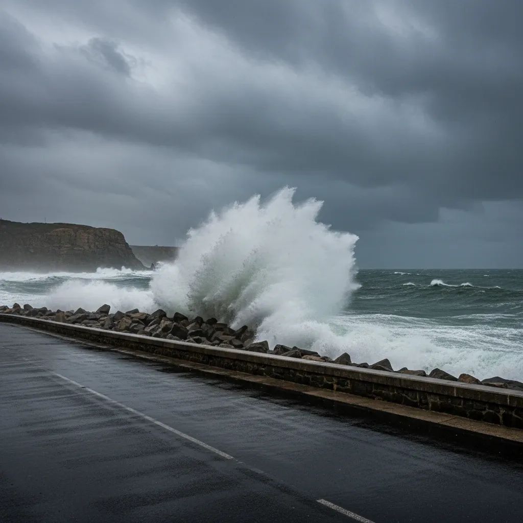
• Atlantic waves near 6 m put fishing fleets and coastal cafés at risk of forced shutdowns during a key Carnival tourism week.
From Joseph to Leonardo: A Relentless Storm Conveyor
Storm “Joseph” battered the Iberian Peninsula in late January, but the Atlantic conveyor belt never stopped. The current culprit, Depression “Leonardo,” has slipped in behind Joseph, Ingrid and Kristin, feeding off an exceptionally strong jet stream. That sequence explains why municipal crews in Porto are still pumping basements mere days after the previous deluge. Meteorologists warn that at least two more frontal systems could sweep across Portugal before mid-February, keeping the soil saturated and river levels high.
Forecast at a Glance
• Rain: Models show a broad swath of the Minho, Douro Litoral and Beira Litoral accumulating 20-30 mm every 6 hours through Thursday night. Lisbon and Setúbal shift into the bull’s-eye on Friday.
• Snow: Freezing levels drop to 1 200 m by mid-week, meaning fresh snow for Torre but also potential ice on the A-24 viaducts.
• Wind: Coastal gusts of 75 km/h will likely peak Wednesday evening; upland gusts may exceed 95 km/h around Montalegre and Guarda.
• Sea state: Western shores from Viana do Castelo to Leiria should brace for significant wave heights of 5-6 m, with maximum sets up to 11 m during high tide Wednesday morning.
What This Means for Residents
• Homeowners: Inspect roof tiles and clean gutters now; insurers frequently deny payouts when basic maintenance is neglected.• Drivers: Expect rolling closures on the A-23, A-25 and EN-2 mountain stretches; pack chains if crossing Serra da Estrela.• Commuters: Comboios de Portugal already warns of speed restrictions north of Coimbra; delays may ripple into Alfa Pendular timetables.• Remote workers: Telecom towers in Bragança and Vila Real suffered outages last month—download essential files in advance.• Small businesses: Coastal cafés in Nazaré and Peniche should secure terrace furniture and confirm coverage for “loss of earnings” linked to civil-authority closures.
How Authorities Are Preparing
The national Proteção Civil has escalated readiness to Level 4 (maximum) in Setúbal and Viana do Castelo, meaning 100 % of firefighting and rescue assets are on 12-hour call. Municipalities from Oeiras to Vila Real pre-positioned pumps, sandbags and cherry-pickers for fallen branches. Coimbra, Mira and Mealhada closed schools Tuesday afternoon, citing unsafe bus routes, and may extend closures if rainfall tops forecast maxima. In the Algarve, maritime police ordered fishing vessels under 9 m to remain in port from Wednesday 06:00.
Travel & Business Disruptions to Expect
Airports usually remain open, but Faro and Madeira often experience wind-shear delays; travellers should monitor airline apps. TAP has already issued flexible re-booking for flights through 8 February. Truckers hauling produce from Andalusia to Lisbon report queue times doubling at the Caia border inspection due to surface flooding. Tourism operators fear last-minute cancellations for Carnival week festivities, traditionally a €200 M boost to the hospitality sector.
Looking Ahead: When Will Skies Clear?
Current ensemble models hint at a brief ridge of high pressure around 9 February, but the North Atlantic Oscillation remains strongly positive—typically a sign that wet, windy spells will return. IPMA will reassess alerts every six hours; residents can enrol for free SMS warnings via the Autoridade Nacional de Emergência e Proteção Civil website. Until then, the watchwords are the same that guided Portugal through January’s storms: drain, anchor, stay informed.


