A window of relative calm is not yet in sight for Madeira. The maritime authority in Funchal has pushed its strong-wind and heavy-sea warnings well into Saturday evening, signalling that the Atlantic is likely to stay restless and that anyone relying on sea connections or coastal activities should rethink their plans. For residents on the mainland who were hoping for a quick escape to the island, this means further travel headaches; for islanders, it is another reminder of how swiftly November can turn from postcard weather to storm-driven isolation.
What has changed since Thursday
The decision to prolong the alerts came after a fresh briefing from the Portuguese Institute for Sea and Atmosphere (IPMA). On Thursday morning officials still spoke of a possible easing before dawn on Saturday. By late afternoon, however, updated models showed a slow-moving depression named Cláudia inching closer than expected, funneling westerly gusts above 60 km/h toward the archipelago. The Capitania responded by extending its notices first to 06:00 and, a few hours later, to 18:00 on 15 November 2025. That extra half-day may sound minor, but for shipping companies, ferry operators and cruise agents it means another cycle of cancellations, rescheduling and mounting costs.
What the forecasts say
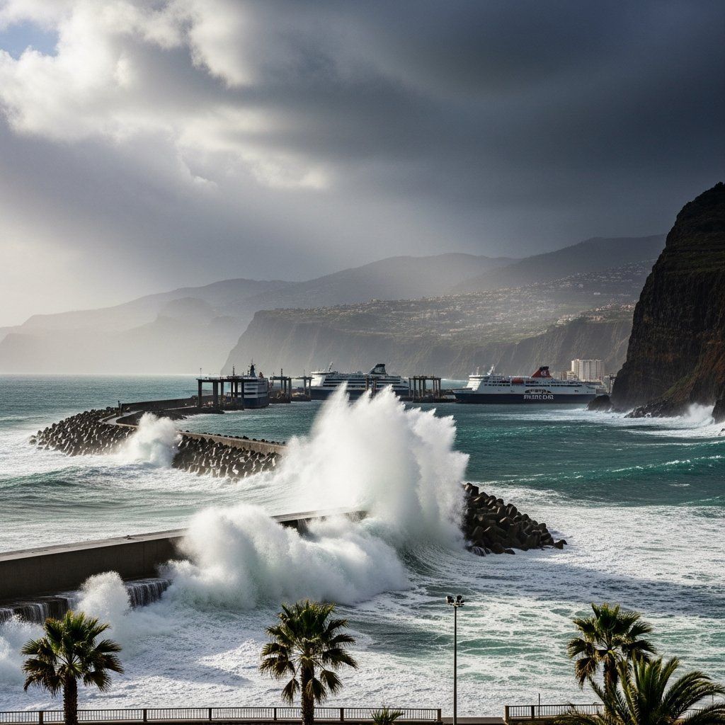
Meteorologists describe a two-part threat. The first component is wind: fresh to very fresh, locally strong across the high ground, with occasional bursts nearing 90 km/h in exposed ridges. The second is agitação marítima—Atlantic swells expected to crest at 3.5 to 4 m along the north coast and up to 3.5 m on the west end of the south shore. While the wind should veer northwest and start losing power by Saturday evening, the sea will take longer to settle, leaving harbours in Câmara de Lobos, Porto Moniz and even the sheltered bay of Funchal grappling with heavy surges. IPMA’s yellow notice for intense showers and isolated thunder remains active through mid-afternoon Saturday, with accumulations that could touch 60 mm in six hours. In Madeira’s steep topography that is more than enough to trigger flash-flood streams racing toward the coast.
Disruptions at sea and on shore
Weather-related downtime is becoming costly. Thursday’s Porto Santo Line ferry never left its moorings, erasing an entire day of passenger and freight revenue. Two luxury ships, "MSC Musica" and "Mein Schiff 7", scratched their calls, an about-face that echoes last winter’s pattern when bad seas forced multiple vessels to bypass Funchal and head for the Canaries. Local traders estimate that each skipped cruise day deprives the downtown economy of €300,000 to €400,000 in direct spending. For the regional government, dependent on tourism taxes, the tally is starting to add up. On the cargo side, supermarkets are confident stocks will last, yet importers of fresh produce admit that any further delay could leave shelves short of specific greens by Monday.
Safety advice for residents and visitors
The Capitania’s language is blunt. Secure your boats with extra mooring lines, keep a constant eye on anchor points, stay off breakwaters and cliff-top trails. Recreational anglers are urged to skip their usual spots on the north-facing escarpments, where rogue waves have claimed lives in past years. Protection Civil teams are on standby in São Vicente and Ponta do Sol, ready to close coastal roads if rockfalls begin. Hoteliers have been asked to inform guests in at least four languages that evening strolls along the harbour wall could be hazardous. For anyone hoping to photograph the swell, authorities recommend doing so from elevated, paved viewpoints, not from wet boulders sprayed by the surf. The guidance applies just as much to continental visitors landing at Cristiano Ronaldo Airport: keep excursions inland until the sea calms.
Looking ahead
Late Saturday the models forecast a weak ridge pushing in from the Azores, nudging Cláudia eastward and offering a short weather window on Sunday. If that holds, ferry services could resume with limited capacity, and the backlog of cruise arrivals might shrink by Monday night. Yet seasoned skippers point out that mid-November often delivers a second pulse of Atlantic lows. Should another one line up next week, the Capitania is prepared to escalate to Sinal 6 – Mau Tempo, the flag that effectively shutters maritime tourism. For Madeira, whose economy still leans heavily on its maritime lifeline, the next 48 hours will show whether Cláudia was a singular annoyance or the opening act of a turbulent late autumn.


