The latest set of weather warnings for Madeira may have expired overnight, yet the episode has once again underlined how quickly the Atlantic can turn against the archipelago and anyone who earns a living—or seeks leisure—at sea. From speeding gusts to walls of water, the past 48 hours forced harbour masters, ferry operators and visiting cruise liners to scramble, while residents on the mainland watched another real-time lesson in island vulnerability.
Gusts Rattle Madeira Again
A strong wind alert first issued on Monday by the Capitania do Porto do Funchal was prolonged twice before ceasing at dawn. It covered the whole maritime fringe of the region, flagging south-westerly gusts climbing up to 74 km/h and, later, a shift to the northwest. The maritime turbulence prompted the harbour master to keep a yellow warning in place for longer than originally planned, a rare but not unheard-of step. Port communities from Caniçal to Porto Santo reported sporadic spray overtopping breakwaters, while airport anemometers at Santa Catarina clocked bursts above 110 km/h over the central ridge.
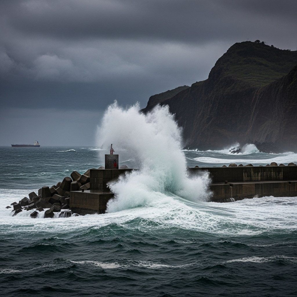
What the Sea Is Doing
Along the north coast the Atlantic delivered swells reaching 4.5 m, high enough to close small fishing ports for hours. On the south-facing shoreline, waves climbed from 1.5 m to 4 m within a single tide cycle, a pattern that IPMA forecasters say becomes more common whenever deep lows skirt the Azores high. Even Porto Santo, normally shielded by Madeira’s bulk, recorded consistent 4 m breakers. Visibility oscillated between “good” and “temporarily poor”, complicating night navigation for cargo ships rounding Cabo Girão.
Alerts and Practical Safety Advice
Madeira’s harbour master distilled the danger into three clear directives: tighten moorings, stay off exposed promenades and suspend recreational angling on cliff ledges. Compliance was noticeably higher this time, possibly because social media footage of a rogue wave sweeping a car at Ribeira Brava in July is still fresh in local memory. Cruise lines repositioned, with one 2,900-berth vessel skipping its Funchal call to sit out the blow in Las Palmas.
Pattern Behind the Warnings
Meteorologists now log dozens of severe-wind notices every year for the Madeira sea area; just five years ago the annual tally rarely hit double digits. Climate-adaptation researchers at the University of Lisbon point to warmer Atlantic surface temperatures and a northward-shifting storm track as accelerants. The regional government, meanwhile, is spending €12 M on raising breakwater crests in Machico and Câmara de Lobos, acknowledging that the old 1-in-50-year design criteria no longer hold.
Why Mainland Should Take Note
For residents on the continent this story offers more than a weather curiosity. Madeira is effectively Portugal’s advance outpost in the Atlantic, often feeling the first shockwaves of systems that later brush the Algarve or send western-swell surges toward Nazaré’s fabled break. Shipping bound for Setúbal or Sines routinely relies on data from Funchal’s coastguard radar before plotting a course up the mainland’s busy EEZ.
Forecast at a Glance
The immediate threat is easing, but forecasts still promise 30-50 km/h gusts today, sliding to the low twenties tomorrow. Swells on the north face should relax to 2.5–3 m by Friday, the south coast dipping under 2 m in the same window. Periods of light rain will alternate with sunny spells, and day-time highs should hover around 24 °C—normal for a Madeiran late October, yet a reminder that the line between postcard weather and hazard is narrowing each season.


