Depression Therese has swept through Portugal's Atlantic archipelagos with wind gusts reaching 110 km/h and eight-meter waves, forcing the cancellation of nearly 20 flights at Madeira Airport and triggering 57 civil protection incidents across the Azores.
Why This Matters:
• Travel disruption: Madeira Airport restricted operations from 12:30 onward on March 19, with 10 arrivals and 9 departures cancelled and 6 aircraft diverted to alternate airports.
• Infrastructure damage: Most incidents in the Azores involved fallen trees and collapsed structures, though no fatalities have been reported.
• Rare cold snap: Temperatures in the Azores dropped to an unusual 3-5°C, with snow possible down to 500 meters altitude—a phenomenon locals rarely see.
• Extended warning period: The Portugal Institute for Sea and Atmosphere (IPMA) maintains orange and yellow alerts through at least Friday, March 20, with full normalization not expected until the weekend.
Storm Strikes Hardest in São Miguel, Disrupts Island Life
The Azores Regional Civil Protection Service (SRPCBA) recorded the bulk of weather-related emergencies on São Miguel island, where 31 incidents occurred—more than half the archipelago's total. The Terceira island logged 13 events, Pico reported 7, Faial saw 5, and São Jorge registered a single case.
Firefighters, municipal civil protection teams, the Portugal Public Security Police (PSP), regional public works crews, forestry officers, and technicians from EDA - Eletricidade dos Açores fanned out across affected zones to clear debris and restore power lines. Coordination remained smooth despite the volume of calls, according to the SRPCBA statement released this morning.
Orange Alerts, Rare Snowfall, and a Polar Intrusion
The depression—christened by the IPMA Azores delegation—originated west of the Portuguese mainland and has been battering the islands since Tuesday, March 17. What sets Therese apart from typical Atlantic disturbances is the polar air mass trailing in its wake, pushing minimum temperatures into single digits and raising the spectre of snow at elevations as low as 500 meters on the Central and Eastern island groups.
That is an unusual spectacle for an archipelago accustomed to mild, maritime winters. Normally, even March mornings hover around 10-12°C at sea level; this week, inland valleys woke to frost and breath-clouds. The IPMA issued orange warnings—the second-highest tier, indicating moderate-to-high meteorological risk—for wind and maritime agitation across the Central (Graciosa, Terceira, São Jorge, Pico, Faial) and Eastern (São Miguel, Santa Maria) groups, while yellow alerts covered the Western islands (Flores and Corvo) for gusts up to 95 km/h.
Wave heights climbed to eight meters in exposed coastal zones, prompting harbourmasters to suspend inter-island ferry services and advise small-craft operators to remain in port. Several cargo vessels delayed unloading at Praia da Vitória and Ponta Delgada, compounding supply-chain friction for supermarkets and fuel distributors.
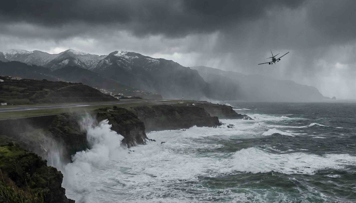
Madeira Airport Chokes Under Combined Weather Front
On the Madeira archipelago, the same low-pressure system wreaked havoc at Madeira International Airport, one of the busiest island gateways in the North Atlantic. According to real-time data published by ANA – Aeroportos de Portugal, morning operations ran smoothly until 12:30, when crosswinds and visibility constraints forced air-traffic controllers to impose restrictions.
By 17:00, ten inbound flights had been cancelled, nine departures scrubbed, and six aircraft diverted to Porto Santo, Lisbon, and—in one case—Gran Canaria. Stranded passengers filled the terminal's cafés, rebooking counters stretched wait times past two hours, and hotel shuttles ran a continuous loop to accommodate overnight stays.
The IPMA layered orange warnings over Madeira's mountainous interior for wind, paired with yellow alerts for heavy precipitation, maritime agitation, and snowfall above 1,200 meters. The Madeira Regional Civil Protection Service cautioned residents to brace for deteriorating conditions through at least Friday, March 20, highlighting the north coast and high-altitude zones as particularly vulnerable.
Forecast models called for showers—sometimes intense, accompanied by hail and thunderstorms—across both Madeira Island and Porto Santo. Wind velocities were projected to hit 70 km/h in lowland areas, 90 km/h on ridges, and spike temporarily to 110-120 km/h in the most exposed peaks. On the north coast and around Porto Santo, wave heights of 4-5 meters rolled in from the northwest, with localized peaks of 10-12 meters expected by Friday evening along the southern shoreline.
What Residents and Travelers Should Know Now
If you have flights booked to or from Madeira or the Azores through March 20, check your airline's app or call centre regularly; schedules remain fluid. Trip-cancellation insurance policies typically cover force-majeure weather events, but documentation—screenshots of cancellation notices, IPMA alert bulletins—will smooth any claim.
Ferry services will resume as soon as harbour authorities lift maritime-agitation alerts, likely by midday Saturday for most routes. Air traffic at Madeira Airport should return to full capacity by late Friday evening, though knock-on delays from cancelled flights may ripple into the weekend timetable.
For travellers whose plans were upended, rebooking windows vary by carrier. SATA Air Açores and Azores Airlines generally allow free date changes within seven days of a weather cancellation; low-cost operators flying into Madeira from Lisbon or Porto may charge change fees unless your ticket included flexible rebooking. Check the fine print and escalate to customer service if the initial response feels inadequate.
When Normalcy Returns
The IPMA expects conditions to stabilize by Saturday, March 21, with Depression Therese drifting northeast toward the British Isles. Winds should slacken to 30-40 km/h by Sunday morning, wave heights will retreat below 3 meters, and temperatures will nudge back toward seasonal norms of 12-15°C.
Municipal crews will spend the coming days clearing fallen timber, inspecting road culverts for blockages, and cataloguing damage claims. Business-interruption filings typically spike in the fortnight following any major weather event, so self-employed professionals and small-business owners should photograph losses and preserve receipts for insurance documentation.