The Portugal Institute of the Sea and Atmosphere (IPMA) has activated yellow-level weather warnings for the Madeira archipelago, targeting heavy rainfall and rough seas over the next 72 hours—a reminder that mid-March can still deliver unpredictable Atlantic weather to the islands.
Why This Matters
• Rain Warning: Strong showers with thunderstorms expected Tuesday, March 17, from 12:00 to 21:00 UTC across Madeira and Porto Santo.
• Sea Alert: Waves reaching 4–5 meters will hit northern and southern coasts from Wednesday afternoon through Thursday noon (18–19 March).
• Travel Impact: Ferry services, coastal tours, and port operations may face delays or cancellations during peak wave periods.
What Yellow Warnings Mean for Residents and Visitors
Yellow alerts represent the lowest tier in Portugal's three-level weather warning system, but they signal genuine risk for outdoor activities, maritime transport, and coastal infrastructure. The classification triggers precautionary measures across sectors dependent on stable weather—fishing fleets, inter-island ferries, and recreational boat tours typically reduce operations or suspend departures altogether when seas exceed 4 meters.
For the Portugal Funchal Port Authority, these conditions mean heightened coordination with vessel operators. Historical patterns show that even yellow-level sea warnings prompt restrictions on smaller craft and tourist boats, particularly those servicing Porto Santo routes or dolphin-watching excursions along Madeira's exposed northern coastline.
Residents in low-lying coastal areas and near steep terrain should remain alert during the precipitation window on Tuesday. While thunderstorms lasting nine hours may not rival the catastrophic floods of 1984 or the debris flows of December 2020, they can still trigger localized flash flooding and rockslides on Madeira's mountainous roads.
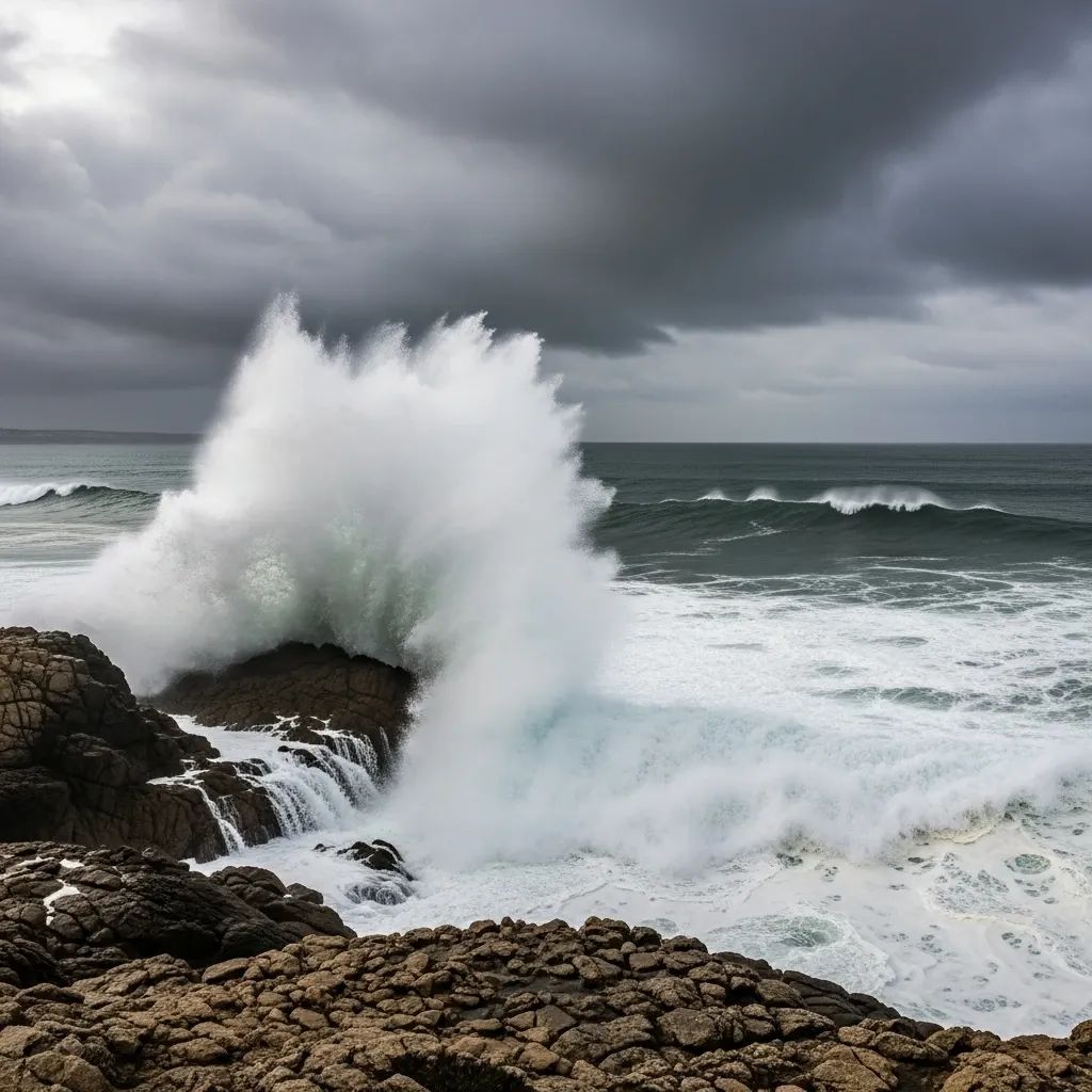
Wave Heights and Wind: The Maritime Reality
The IPMA forecasts northwest swells of 4–5 meters battering Madeira's north coast and Porto Santo, with southwest waves of 4–4.5 meters rolling into the southern shore's western section. These figures may sound moderate to seasoned mariners, but for the archipelago's steep coastal topography, such conditions create hazardous surf zones and complicate port operations.
March has delivered similar maritime turbulence in recent years. In March 2024, the institute issued warnings for waves reaching 5–6 meters, prompting the Portugal National Maritime Authority to advise against all non-essential coastal activities. The following year, Storm Martinho swept through the islands between March 18–20, combining strong winds, intense rain, and rough seas—a pattern that underscores the Atlantic's capacity for sudden weather shifts during the spring transition.
This week's alert period runs from Wednesday at 15:00 UTC through Thursday at 12:00 UTC, with the most intense wave action expected overnight. Travelers planning ferry trips to Porto Santo or coastal hikes should monitor updates from the IPMA and local port authorities, as schedules can shift with little notice.
Precipitation Patterns: A Variable Month
March typically marks a drying trend for Madeira, with rainfall probability dropping from 16% early in the month to just 10% by month's end. Average accumulation slides from 29 millimeters to 16 millimeters—but these are statistical norms, not guarantees. The islands have witnessed extremes during this period: March 1984 brought devastating floods and coastal damage, while March 2023 entered the record books as the warmest and driest on file.
Tuesday's forecast calls for intermittent heavy showers and thunderstorms across the north coast, mountainous interior, and south coast of Madeira, plus Porto Santo. The nine-hour warning window suggests a frontal system passing through rather than a persistent weather pattern. Still, the combination of steep terrain and saturated soils from earlier rainfall can amplify flash-flood risk, particularly in valleys and urban drainage zones around Funchal.
The Portugal Civil Protection Authority advises residents to download the Prociv Madeira app, which provides real-time alerts, emergency contact numbers, and GPS location sharing for critical situations. The app proved valuable during past weather events, allowing authorities to coordinate evacuations and road closures swiftly.
Impact on Daily Life and Tourism
For the estimated 1.3 million annual visitors to Madeira—many of whom arrive in March seeking spring sunshine—weather alerts can disrupt itineraries. Popular levada walks in the mountains may close during or after heavy rain due to slippery trails and rockfall hazards. The regional government maintains a dynamic list of closed hiking routes, updated daily based on conditions and safety inspections.
Coastal activities face the most direct impact. Surf schools, diving operators, and yacht charters along the south coast typically suspend bookings when wave heights exceed 3.5 meters. The Porto Santo ferry, a critical inter-island link, adjusts its schedule based on real-time sea conditions—yellow warnings often translate to delayed departures or route cancellations, stranding travelers who underestimate the Atlantic's moods.
Urban areas around Funchal should experience minimal disruption from Tuesday's rainfall, though drivers should anticipate slick roads and reduced visibility during peak shower periods. Madeira's drainage infrastructure has improved significantly since the deadly 2010 floods, but steep streets and narrow alleys in older neighborhoods can still funnel water quickly during intense downpours.
Historical Context: When Atlantic Weather Strikes
Madeira's geography—an isolated volcanic archipelago rising sharply from the ocean—makes it vulnerable to rapid weather intensification. The islands sit in the path of North Atlantic frontal systems, which can deliver concentrated bursts of wind, rain, and swell with limited warning.
Recent March events illustrate this volatility. In 2024, forecasters tracked multiple low-pressure systems sweeping northeast from the Azores, generating sustained winds up to 70 kilometers per hour and waves topping 6 meters. The 2025 storm season brought Martinho's fusion of heavy rain, gale-force winds, and rough seas—a three-day event that closed ports, grounded flights, and triggered landslide alerts across the island.
While severe droughts and catastrophic floods have not plagued Madeira in the past three years, the archipelago remains prone to sudden hydrological events. Studies of the December 2020 and January 2021 floods noted parallels to earlier disasters in 2009, 2012, and 2013, when torrential rain overwhelmed drainage systems and triggered debris flows in steep valleys.
Safety Protocols and Emergency Numbers
The Portugal emergency hotline—112—remains the primary contact for urgent situations, including maritime distress, medical emergencies, or immediate hazard reports. The Prociv Madeira app supplements this with push notifications for weather warnings, road closures, and evacuation orders.
Specific safety guidance for this alert period includes:
• Avoid coastal promenades and rocky viewpoints during the sea warning window (Wednesday afternoon through Thursday midday).
• Check ferry schedules before traveling to Porto Santo; operators often cancel morning departures if overnight conditions persist.
• Postpone mountain hikes scheduled for Tuesday; wait 24 hours after heavy rain for trail inspections.
• Secure loose outdoor items (furniture, planters, tarps) that strong winds could displace.
• Monitor IPMA updates via their website or app for possible warning extensions or upgrades to orange level.
Drivers should exercise particular caution on mountain roads, where rain can trigger rockslides or create sudden waterfalls across pavement. Madeira's network of tunnels and bridges typically handles weather well, but older coastal roads—especially the scenic routes along the north shore—may experience temporary closures if wave action threatens infrastructure.
Looking Ahead: Post-Warning Conditions
After Thursday noon's sea warning expires, the IPMA forecasts a gradual return to calmer conditions, with decreasing swell heights and lighter winds through the weekend. March's typical pattern of intermittent showers and sunny intervals should reassert itself, allowing tourism and maritime activities to resume normal operations.
However, the Atlantic's spring transition remains inherently unstable. Residents and visitors should maintain situational awareness through local weather services, recognizing that yellow warnings serve as both alert and opportunity—a chance to adjust plans, secure property, and prioritize safety over convenience during the brief windows when Atlantic weather reminds everyone that island life demands respect for natural forces.