
Madeira Storm Alert: Depression Regina Peaks Tuesday, March 3, 2026
Monday, March 2 through Wednesday, March 4, 2026 — Depression Regina is delivering extreme conditions to Madeira this week, with the most violent phase arriving Tuesday. The Portugal Institute of the Sea and Atmosphere (IPMA) forecasts gusts approaching 120 km/h across highlands and waves reaching 11 meters. The archipelago faces substantial transport and tourism disruptions through midweek.
Critical Information for Residents:
• Flights cancelled through Wednesday morning: The Madeira Airport Authority (ANA) cancelled roughly 50% of scheduled operations Monday. Full airport resumption expected Wednesday afternoon once crosswind safety limits are met again.
• Recreation and outdoor activity prohibited: All recreational fishing, cliff-edge access, and levada trail hiking closed until Wednesday. Maritime operations severely restricted.
• Mountain roads closing Tuesday: Snow expected above 1,500 meters combined with 120 km/h winds will force preemptive closures on Pico Ruivo and Pico do Areeiro access routes.
• Timeline for improvement: Conditions improve significantly Wednesday morning; near-normal weather returns by Thursday.
Why This Storm Hits Madeira So Hard
Depression Regina struck mainland Portugal on Monday as a relatively contained system. The IPMA reported scattered thunderstorms and moderate rainfall across central and southern regions, with wind speeds peaking near 60 km/h—manageable conditions with no major disruptions.
The system transforms dramatically over Atlantic waters. By Monday afternoon, atmospheric pressure patterns had repositioned Regina's motion southwestward, placing it directly over Madeira by evening. This occurs because warm ocean waters accelerate depressions rather than diminish them. Regina, crossing waters averaging 17 to 18°C in early March, gained energy and organization as it advanced toward the island.
The first assault arrived Monday evening with 80 km/h coastal gusts and 110 km/h wind speeds across interior plateaus. Wave energy climbed to 4 to 5 meters, with isolated swells reaching 7 to 8 meters by nightfall.
Tuesday Peak: When Conditions Become Genuinely Hazardous
Tuesday, March 3, shifts the threat profile entirely. The depression's center moves closer to the island while its wind field tightens—producing the strongest gusts of the entire system's passage. The IPMA forecasts north-northwest winds with sustained gusts of 95 to 120 km/h across the island, with peak intensity on ridge-lines and exposed slopes.
The Chão do Areeiro meteorological station at 1,600 meters elevation provides the benchmark for highland conditions. During Depression Emília in December 2025 (just three months prior), this location registered 147 km/h gusts, producing 353 civil protection incidents across the island. Regina's forecasts predict marginally lower extremes but comparable operational consequences.
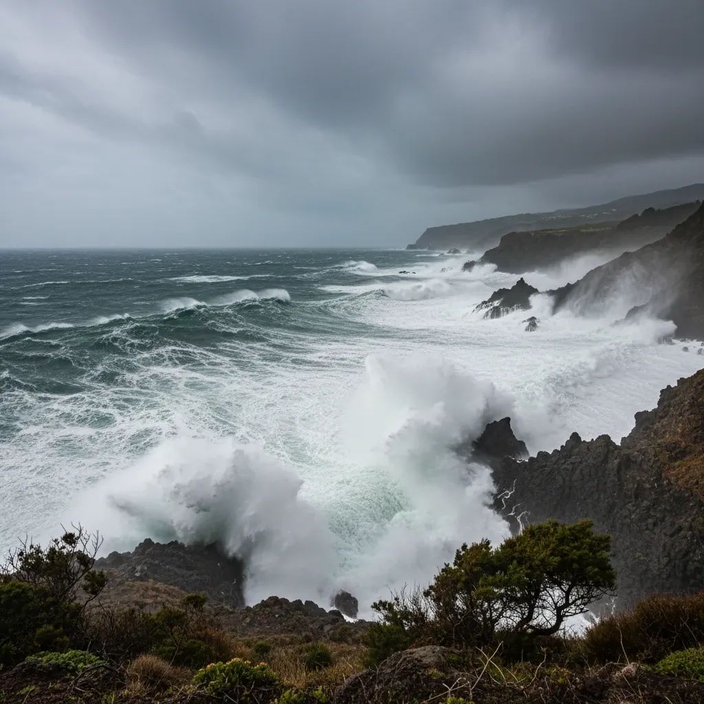
Coastal communities experience sustained gusts near 95 km/h—sufficient to snap tree branches, displace lightweight construction materials, and create visibility hazards. Simultaneously, the ocean develops 5 to 6 meter significant wave height, with the largest individual swells reaching 11 meters. These conditions are unsuitable for any water activity and dangerous near harbors.
By Tuesday evening, conditions begin a gradual retreat. Wednesday morning brings perceptible improvement; coastal locations drop below the 60 km/h crosswind threshold by mid-afternoon, rendering airport operations feasible once again.
The Airport Crisis: Safety Thresholds Override Economics
The Madeira Airport Authority (ANA) operates the archipelago's single commercial aviation hub on the south coast near Funchal. This geographic position makes every northerly gale an operational constraint, as crosswinds channel directly across the runway without natural terrain shelter.
As of Monday morning at 09:30, ANA's flight operations portal displayed 50 cancelled flights (roughly 26 arrivals and 24 departures)—approximately 50% of planned movements. This reflects hard meteorological physics: Boeing 737 and Airbus A320 aircraft operating Funchal routes carry published crosswind limits of approximately 40 to 45 knots (73 to 82 km/h) depending on aircraft weight and braking conditions. With 80 km/h winds already present and forecast to intensify to 95 to 120 km/h, operations became mathematically impossible.
TAP Air Portugal (operating roughly 40% of Funchal schedules), EasyJet, Lufthansa, TUI Airways, and smaller operators implemented immediate rebooking protocols, contacting passengers by SMS and email directing them to contact reservation systems.
Critical passenger guidance: Verify flight status directly with your carrier rather than relying on airline websites, which update slowly during dynamic weather events. Conditions can shift hour-to-hour as meteorological models update; showing up at the airport without current confirmation wastes time and fuel.
For the tourism-dependent economy, this disruption creates meaningful revenue leakage. Hotels incur staffing costs for extended occupancy without new check-ins; restaurants experience disrupted service patterns; tourism operators lose guide revenue from cancelled excursions. However, disruptions of this magnitude are neither unprecedented nor catastrophic within Madeira's experience.
What Actually Closes: Recreation, Outdoor Activity, and Movement Restrictions
The Capitania do Porto do Funchal (Maritime Port Authority) issued mandatory prohibitions on all recreational fishing activities within coastal rocks and cliff-edge zones. The combination of 95 to 120 km/h winds with 5 to 6 meter wave height creates immediate fall risk and drowning hazard; any person swept into the water faces near-certain fatality through hypothermia and undertow.
The famous levada hiking trails—centuries-old water channels engineered into steep mountainsides and Madeira's signature tourism attraction—will close through at least Wednesday morning. These trails concentrate foot traffic on exposed ridgelines and narrow ledges where falling branches, displaced rocks, and loss-of-footing risk escalate dramatically during high wind events. Tourism operators have already notified clients of trail suspensions.
Older residential areas face elevated wind damage risk. The Serviço Regional de Proteção Civil (Regional Civil Protection Authority) recommends that property owners verify exterior condition, secure moveable items (potted plants, patio furniture, garbage containers), and trim overhanging branches. Property insurance claims for weather-related damage spike predictably following severe wind events.
Agricultural impacts concentrate on exposed hillside plots where wind-driven soil erosion and potential hail damage affect crop viability. Madeira's banana cultivation and wine grape production occupy exposed slopes where wind stress damages fruit and leaf structure.
The Unusual Phenomenon: March Snow at Altitude
The IPMA forecasts snowfall above 1,500 meters altitude on Tuesday—a meteorologically unusual but not unprecedented occurrence for Madeira in early March. The Pico Ruivo and Pico do Areeiro summits will likely accumulate 3 to 8 centimeters of wet snow.
The phenomenon itself is visually spectacular and generates social media content. However, the coincidence of heavy snow with 120 km/h wind speeds creates operational hazard rarely experienced. Snow-covered mountain roads combined with high crosswind forces, reduced visibility from active snowfall, and black ice formation create conditions unsuitable for routine driving. The Regional Civil Protection Authority will issue mountain road closures preemptively Tuesday morning rather than manage rescue operations afterward.
The IPMA's yellow-level snow alert accurately reflects the risk profile. Yellow alerts indicate "potential risk for certain activities dependent on weather conditions" rather than widespread public hazard. Snow itself poses minimal danger to the overall population at lower elevations, but snow combined with extreme wind and treacherous road conditions creates genuine danger for mountain visitors.
Essential Services Activation and Contingency Status
While the Regional Civil Protection Authority has not published specific departmental contingencies, historical patterns provide reasonable indication of preparations. Electricity distribution networks, particularly vulnerable to wind-driven tree damage, likely operate pre-positioned repair crews and mobile transformer units near known grid vulnerability points. Depression Emília caused significant localized outages affecting several communities for extended periods.
Water systems similarly activate redundancy protocols. The Empresa de Água e Electricidade da Madeira (EDEM) likely increases field crew staffing and pre-positions emergency repair capacity. Hospital systems implement pre-event scheduling adjustments: elective surgeries move earlier in the week, and emergency department capacity expands. Ambulance services pre-stage units strategically and increase overnight staffing.
Civil protection remains accessible through emergency numbers 112 or regional dispatch, though volume-dependent delays should be anticipated during peak weather impact windows. Non-life-threatening incidents experience extended response delays as resources concentrate on active emergencies.
Historical Context: Madeira's Storm Resilience
The February 20, 2010 disaster remains the historical benchmark. That event killed 47 people, left 4 missing, displaced 600 residents, and injured 250. A powerful frontal system originating from the Azores produced unprecedented precipitation concentration, spawning catastrophic flash flooding, landslides, and debris flow. Depression Regina presents no indication of approaching that magnitude—wind forecasts are notably lower, and precipitation predictions remain modest.
Depression Oscar (June 2023) established a different marker: the Portugal all-time 24-hour precipitation record of 497.5 millimeters. Oscar's dynamics involved sustained tropical moisture transport distinct from Regina's current configuration.
Depression Emília (December 2025—just three months ago) more closely parallels Regina's profile. Emília generated 147 km/h gusts at highland monitoring stations, spawned 353 civil protection incidents, and delivered 91 millimeters of rainfall in 24 hours. Current Regina forecasts predict marginally lower wind extremes but comparable operational disruption patterns.
The island's exposure to Atlantic storm systems reflects its geographic position in a convergence zone where weakening tropical systems occasionally track toward African waters. When directional patterns align favorably for Madeira-focused impact, the archipelago experiences concentrated wind and precipitation effects.
The Recovery Timeline and Return to Normalcy
By Wednesday morning, March 4, residents should perceive tangible improvement. Wind speeds diminish through the day; coastal gusts drop below the 60 km/h airport crosswind threshold by mid-afternoon, rendering flight operations feasible once again. Highland zones retain elevated winds longer, but the 120 km/h peak passes definitively by Wednesday morning.
Thursday, March 5, enters a transition phase toward seasonally normal conditions. Partly cloudy skies dominate; winds remain light and variable. Scattered showers continue affecting elevated areas but intensity remains typical. This weather pattern should remain stable through the weekend, establishing a return to tourism and commerce normalcy.
For travelers whose flights were cancelled or rescheduled, Thursday and Friday represent primary rebooking windows. However, airline backlogs from massive flight displacements may persist beyond meteorological improvement. Contact carrier representatives directly to verify rebooking status—manual confirmation remains prudent given system volume pressures.
Tourism operators will reschedule outdoor excursions beginning Thursday afternoon. Levada trail inspection crews will assess safety conditions; reopening announcements typically follow within hours of clear inspections. Boat charter services will resume operations once harbor conditions demonstrate sustained normalization.
Madeira's resilience through repeated severe weather events reflects geographic adaptation and professional institutional emergency management practice. The island absorbs these systems with measured response, sustained operational disruption measured in hours to days rather than weeks, and rapid recovery embedded into community expectation and established protocol.


