The Portugal Meteorological Institute (IPMA) has placed the Madeira archipelago under orange alert for severe maritime conditions, with Porto Santo and the northern coast of Madeira affected from Wednesday afternoon through Thursday midday. The elevated warning has already forced the suspension of ferry services and flight operations between the islands.
Why This Matters:
• Ferry cancellations: The Lobo Marinho vessel has suspended all voyages for Wednesday and Thursday, cutting the primary link between Madeira and Porto Santo.
• Flight disruptions: Binter has cancelled flights on Tuesday morning due to deteriorating conditions.
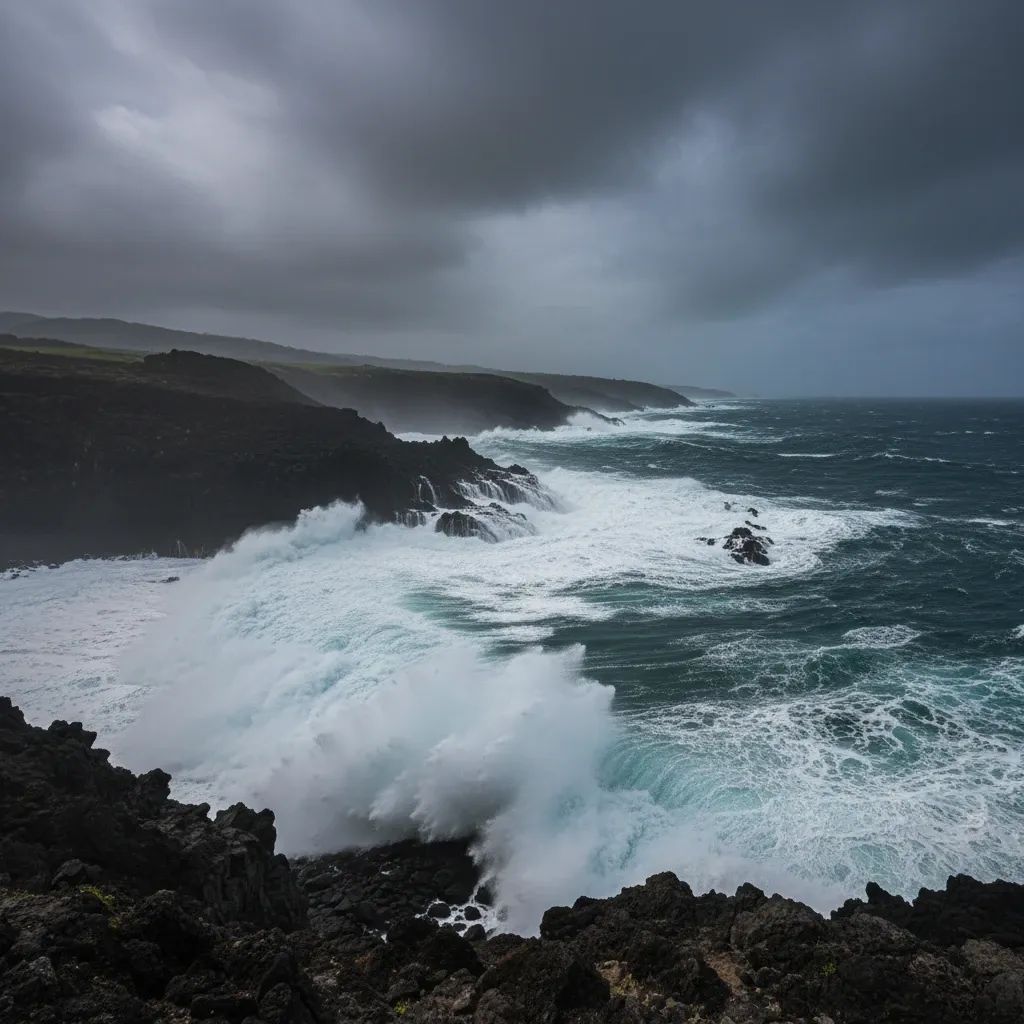
• Wave heights: Northwestern swells will reach 5 to 7 meters on average, with maximum wave heights potentially hitting 12 meters during the peak period.
• Transport isolation: Porto Santo faces significant disruption to its transport services, amplifying concerns about essential goods supply and tourism.
Orange Alert Triggers Transport Shutdown
The orange alert, Portugal's second-highest warning level, activates from Wednesday afternoon through Thursday midday. Prior yellow alerts had been in place since Tuesday morning, with conditions worsening as northwestern weather systems moved across the region.
Porto Santo Line, the ferry concession operator linking the islands, cancelled scheduled sailings for April 8 and 9 after reviewing the updated forecasts. The company arranged additional departures on Tuesday to accommodate passengers and freight ahead of the maritime lockdown.
Wind and Rain Compound Hazards
The entire Madeira archipelago falls under yellow alert for wind. Mountainous regions face the greatest exposure, with gusts expected to reach 110 km/h in elevated terrain. Coastal zones on both the northern and southern shores may experience gusts up to 80 km/h, sufficient to topple unsecured outdoor structures and vegetation.
The Funchal Harbor Master's Office extended its maritime warning through the full duration of the orange alert period. Maritime advisories emphasize reinforcing mooring lines, conducting frequent checks on anchored and docked vessels, and avoiding recreational fishing near cliffs and coastal areas vulnerable to wave impact.
Precipitation is also expected, with rain showers anticipated across the northern slopes and mountainous interior. Humidity levels will climb significantly, creating slippery road conditions and elevated landslide risk on steep slopes.
What This Means for Residents and Visitors
For anyone planning travel to or within the archipelago, the immediate message is clear: defer non-essential trips until conditions stabilize. The combination of high seas, gusty winds, and rain creates hazards across multiple transport modes.
The Portugal Civil Protection Service (SRPC, IP-RAM) issued protocols urging residents to secure loose outdoor items such as awnings, scaffolding, and garden furniture. The agency also recommends avoiding coastal zones including sea walls, beaches, and cliff edges, where wave surge can exceed typical breakwater defenses. Motorists should reduce speed, watch for standing water on roadways, and avoid flooded sections.
Drainage systems warrant particular attention. Property owners and municipal crews are advised to clear storm drains and remove debris that could obstruct water flow, reducing the likelihood of localized flooding in urban areas and along stream channels.
For Porto Santo specifically, the transport interruption affects the island's economy, which relies heavily on regular maritime connectivity for tourism and essential goods supply. Limited air connectivity and the inability to transport vehicles or bulky cargo by plane restrict alternatives during weather disruptions.
Recovery Timeline
The orange alert expires at 12:00 Thursday, with wave heights and wind speeds expected to diminish gradually through the morning. However, Thursday may still bring rain and persistent humidity, maintaining slippery conditions on roads and trails.
For mariners and coastal businesses, the return to normalcy depends on sustained improvement in sea state. Ferry operators typically require wave heights below 4 meters for safe passenger operations, meaning Thursday afternoon sailings remain uncertain pending real-time assessments.
Authorities stress that residents should monitor official channels for updated warnings and comply with access restrictions to high-risk zones. The convergence of maritime, wind, and precipitation hazards demands heightened vigilance and conservative decision-making, particularly for activities dependent on stable weather conditions.