A thick swell rolling in from the North Atlantic is once again rewriting weekend plans along Portugal’s western shoreline. Three northern districts remain under an Aviso Laranja—the country’s second-highest maritime warning—while another seven stretch of coastlines are on Aviso Amarelo. For residents from Viana do Castelo down to the Setúbal Peninsula, the message is clear: the sea will be the main protagonist of the next 48 hours.
Quick Take
• Porto, Viana do Castelo and Braga stay under the most serious orange alert for waves until the early hours of Saturday.
• Forecasts point to north-westerly swell of 5 – 5.5 m, with individual crests approaching 10 m.
• Further south, Lisboa, Setúbal, Faro & Beja move between yellow and orange phases as the system migrates.
• Maritime bars from Caminha to Cascais are closed or heavily restricted—expect knock-on effects for fishing fleets and ferry connections.
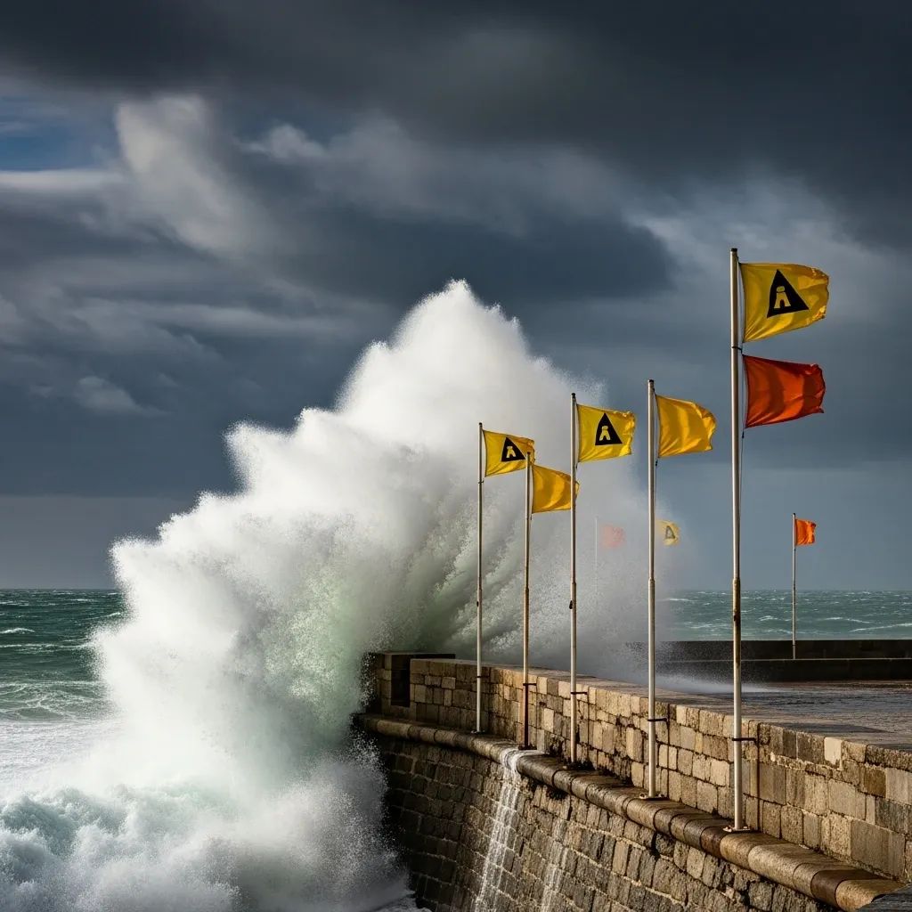
What the Orange Alert Really Means
The Portuguese Institute for Sea and Atmosphere (IPMA) reserves the Aviso Laranja for situations of “moderate to high risk” at sea. In practice, that translates to powerful long-period waves, occasional wave run-up across promenades, and an elevated chance of coastal overtopping. Emergency officials warn that even breakwaters which appear safe can be swept by sudden 10-metre surges, an observation backed by the Port of Leixões harbour master in his latest safety bulletin.
District-by-District Snapshot
Although the North is bearing the brunt, the entire façade from Minho to the Algarve will feel the storm’s wash. Key figures:
Porto – 5.5 m significant height, peaking late this evening.
Viana do Castelo – frequent 5 m sets, bar restricted to vessels < 11 m.
Braga – exposed beaches at Esposende recording the highest spray.
Aveiro & Coimbra – downgraded to yellow, but Figueira da Foz bar remains shut.
Leiria – Nazaré Canyon focusing energy, surfers told to stand down.
Lisboa – two yellow windows separated by a brief overnight lull.
Setúbal, Beja, Faro – 4 m rollers, enough to disrupt Sado and Guadiana crossings.
Why Are the Waves So Impressive?
Meteorologists attribute the episode to a deep Icelandic low that swept an arctic maritime air-mass over warmer Atlantic water. The resulting pressure gradient generated gale-force westerlies, which have had nearly 3 000 km of fetch to organise into long, tidy periods. Climate scientists also note that warmer global oceans are favouring more energetic winter swells, a trend evident in the 2023-24 season’s record breaker.
Staying Safe on the Coast
Authorities repeat a handful of rules each time the colour charts turn orange, yet accidents still happen. The National Maritime Authority lists five no-debate directives:
• Keep 15 m back from the waterline, even on apparently sheltered piers.
• Cancel any plans for recreational fishing off rocks; fines now top €2 000 if you ignore red-flag notices.
• Verify mooring lines and fenders—several small craft sank last winter in identical conditions.
• Consult the ANEPC civil-protection app; push alerts arrive faster than radio bulletins.
• Drive cautiously on sea-spray-slick roads such as the Marginal in Oeiras.
Ripples Through Transport and Industry
Closed bars up north place an immediate squeeze on the fresh-fish supply chain; Peniche auctioneers already predict 15 % lower landings for the weekend market. Meanwhile, cable ferries on the Douro and Sado have trimmed timetables, and the Port of Lisboa asks container lines to slow steam to avoid bunching when the harbour re-opens. Insurance brokers are expecting a spike in claims for salt-water damage along café terraces built too close to the tide line.
Will Christmas Travel Be Affected?
Forecasters see the swell easing gradually after Saturday dawn, sliding down to 3 – 4 m by late Sunday. If models hold, most Lisboa-Porto rail and road corridors should operate normally for the holiday exodus. Still, an incoming secondary low could re-energise seas north of Cabo Carvoeiro early next week, so anyone eyeing a coastal road trip should keep refreshing the IPMA portal. For now, the safest Christmas photo might be one taken well above the high-tide mark.


