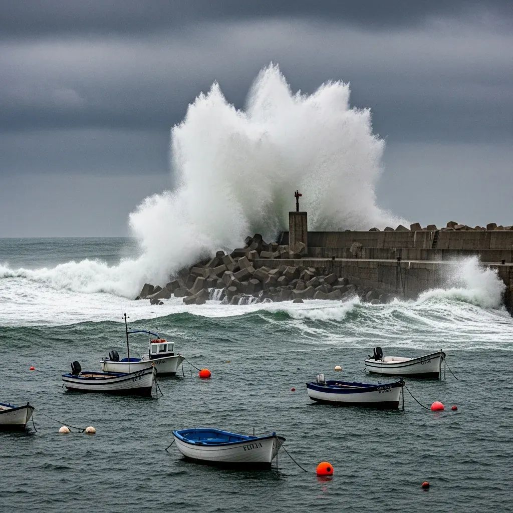
Along the Portuguese coastline, the familiar winter soundtrack of crashing surf is back. An orange-level sea swell alert—one step below the highest—now blankets six districts, prompting officials to warn against seaside strolls, small-boat departures and any impulse to watch the waves up close. For residents from Nazaré to Sagres, the message is straightforward: the Atlantic will dictate the agenda over the next 36 hours.
Snapshot of the Situation
• Districts under orange notice: Lisboa, Leiria, Coimbra, Setúbal, Beja, Faro
• Wave train: northwest sets of 5 – 6 m, peaking near 10 m on exposed breaks
• Strongest window: dawn Tuesday through pre-dawn Wednesday
• Likely impacts: temporary port closures, fishing fleets grounded, disrupted ferry links
• Next downgrade: most alerts expected to shift to yellow before sunrise Thursday
What an Orange Alert Really Implies
Portugal’s colour-coded warning scale often blurs for the public, yet these designations drive port captains and civil-protection units. A level laranja indicates “moderate to high risk”—severe enough for authorities to consider shutting harbour bars, rerouting cargo vessels and activating coastal patrols. In practical terms it signals:
• Wave crests high enough to sweep promenades and car parks.
• Consistent 70-80 km/h gusts that stiffen the sea surface and magnify rogue waves.
• Increased probability that rescuers must launch, putting extra strain on the maritime search-and-rescue chain.Port officials in Peniche, Setúbal and Portimão confirmed they have pre-positioned tugboats and reinforced mooring lines, anticipating surges at high tide.
Hour-by-Hour: How the Swell Unfolds
Meteorologists at IPMA expect the pulse to build in two phases. During the early hours of Tuesday, satellite buoys west of the Cabo Mondego already signalled 4 m seas. By mid-morning, readings climb toward 6 m south of Sintra, with occasional 10 m peaks reported off the Berlengas. The most turbulent stretch should coincide with Tuesday sunset, when north-westerly wind bursts punch through the swell, creating steep, chaotic breakers.
• From midnight to 06:00 Wednesday: alerts ease but remain orange between Figueira da Foz and Sines.• After 06:00 Wednesday: warnings downgrade to yellow for Lisboa and Setúbal; southern districts shift later in the morning.Oceanographers note that this pulse stems from a deep Atlantic depression that sped past the Azores, funnelling energy directly toward Iberia.
Maritime Economy Feels the Pinch
The timing is awkward: December is high season for pre-holiday cargo imports and for coastal communities relying on polvo and dourada landings before Christmas Eve.
• Fishing skippers in Peniche and Baleeira confirmed to Rádio Renascença they will stay berthed, citing insurance clauses that void coverage above 5 m.
• Container terminals at Lisboa (Alcântara) and Setúbal have drafted contingency rosters; cranes slow or halt once wind crosses 45 km/h.
• Tourism operators expecting winter-swell spectators around Praia do Norte warn that conditions, while dramatic, could turn lethal for cliffside observers.These forced pauses hurt margins, yet the consensus among harbour masters is clear: “Better a day lost than a life lost.”
Safety Advice: Simple Rules that Save Lives
Civil Protection keeps the checklist plain:
Park vehicles well away from seawalls and esporões.
Never stand on wet rocks—one mis-timed set can sweep metres beyond previous spray lines.
Secure small craft with double lines and check bilge pumps.
Follow police cordons; fines apply for unauthorised entry to closed piers.For households in low-lying coastal streets, sandbags may be prudent at doorstep level during high-tide windows.
When Will Conditions Normalise?
Forecast models suggest the fetch weakens rapidly after Wednesday lunch. By Thursday, significant wave height drops below 4 m, enough for IPMA to lift all orange advisories. Surfers hunting for XXL conditions in Nazaré will probably miss the jackpot; the swell direction turns too northerly, robbing the canyon of its magnifying effect. Commercial shipping lanes, however, could reopen by late Wednesday evening, pending local harbour pilots’ assessments.
Key Takeaways
• Orange alerts mean business—localised flooding and structural damage can occur even without storms on shore.
• Coast-dependent industries from fishing to ferry lines will absorb short-term losses, but the preventive halt is cheaper than repairs.
• The episode underlines how the Atlantic’s winter mood shapes daily life, commerce and safety protocols across mainland Portugal’s shoreline.
• Expect quieter seas from Thursday onward, yet stay tuned: further depressions often queue up quickly in December.