
The Portugal Institute for Sea and Atmosphere (IPMA) has activated a tiered network of weather alerts for the mainland and both island regions, a decision that will reshape everything from commuter timetables to weekend tourism plans as Depression “Leonardo” sweeps in.
Why This Matters
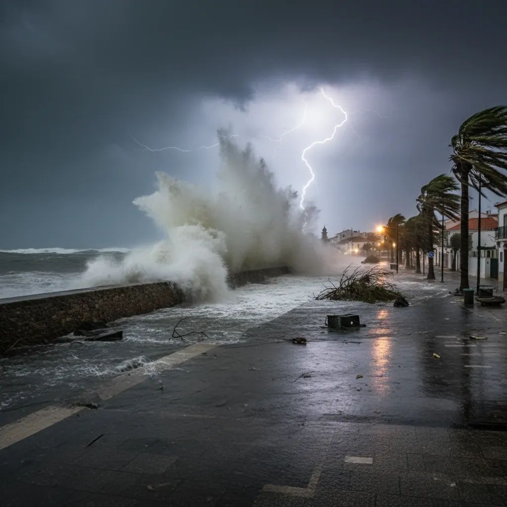
• Flights, ferries and long-distance trains may be delayed or cancelled as gusts approach 95 km/h and Atlantic swells top 6 m.
• Urban flooding and coastal overtopping are likely, especially in Porto, Lisbon and the Algarve’s low-lying resorts.
• Power cuts and fallen trees are expected across interior high ground where wind and wet snow will combine.
• Insurance claims could be challenged if homeowners ignore civil-protection advice on securing loose objects and clearing drains.
The Storm in a Nutshell
Depression “Leonardo” formed west of the Azores and is accelerating toward Iberia, dragging a conveyor belt of subtropical moisture into Portuguese airspace. The system will make its first landfall over the Alentejo this afternoon, then march north-east overnight. Meteorologists forecast a 48-hour burst of persistent, sometimes torrential rain, followed by scattered showers mixed with hail and lightning. At altitude, snow levels will sink from 1 600 m to roughly 1 200 m, coating the Serra da Estrela and potentially shutting mountain roads.
Regional Breakdown: The Hotspots
• South & Southwest (Algarve, Baixo Alentejo) – Heaviest early-phase rainfall; risk of flash floods in coastal gullies.
• Centre-North Interior (Serra da Estrela, Montesinho) – Wet snow and freezing fog overnight, with wind-chill plunging below –5 °C.
• Western Littoral (Aveiro to Peniche) – North-westerly swells up to 11 m at peak, threatening harbour operations and beachfront cafés.
• Azores – Western Group (Flores, Corvo) – Red alert for waves topping 10 m, the most severe classification in the national colour scale.
Official Response & Safety Measures
The Portugal National Authority for Emergency & Civil Protection (ANEPC) has re-activated the winter arm of its National Emergency Plan, streamlining communication between firefighters, police and local councils. Municipal brigades have been ordered to unclog storm drains, reinforce river embankments and cordon off seafront promenades. Residents receive push notifications advising them to:
• Anchor scaffolding, billboards and garden furniture.
• Postpone cliff-top walks and fishing trips.
• Keep a torch, power-bank and battery radio at hand for potential blackouts.
What This Means for Residents
Daily life will slow down. Motorway speed limits may be temporarily cut, and certain high bridges could close to lorries and motorcycles. Expect longer commuting times around Lisbon’s CRIL and Porto’s VCI, where pooling water traditionally clogs underpasses. Parents should plan for possible school schedule changes in mountainous counties if buses cannot run. Homeowners with sea-view apartments face the likelihood of salt-water spray penetrating shutters, so basic maintenance—sealing window frames, storing outdoor cushions indoors—can save expensive repairs. Farmers in the Douro and Mondego basins have a window to clear irrigation channels to avert crop damage.
Business & Infrastructure Concerns
Ports from Leixões to Sines have already issued condition-yellow notices for cargo handling cranes. Forwarding agents fear a backlog as ships slow to ride out the swell. Onshore, renewable-energy output may spike when the strongest gusts spin turbines, yet grid operators caution that storm-triggered outages could offset any surplus. The tourism sector is bracing for last-minute cancellations by surf schools and dolphin-watching charters, while insurers predict a short-term surge in claims for roof tiles and garden walls.
Climate Trend: From Rare to Routine
Climatologists at the University of Lisbon’s Instituto Dom Luiz note that back-to-back depressions—Kristin last week, Leonardo now—are no anomaly but part of a broader pattern of Atlantic extremes amplified by warmer sea surface temperatures. Studies show Portugal invests barely 43 % of the funds experts deem necessary for climate-adaptation infrastructure. Municipalities are therefore urged to factor heavier rains and stronger winds into zoning, drainage and building codes.
Looking Ahead
IPMA models indicate the core of Leonardo will clear mainland Portugal by early Friday, leaving colder air and a parade of short, sharp showers. Another mid-latitude system is possible next week, though confidence remains low. Until then, keep phones charged, stay off exposed cliffs, and give yourself extra time on the road. The worst may pass quickly, but its ripple effects—logistical, financial and personal—could linger well into February.


