The Portugal Institute for Sea and Atmosphere (IPMA) has issued fresh alerts for a vigorous Atlantic system expected to sweep across the country from late Sunday, a shift that could push rivers past flood stage and snarl Monday morning commutes in every major city.
Why This Matters
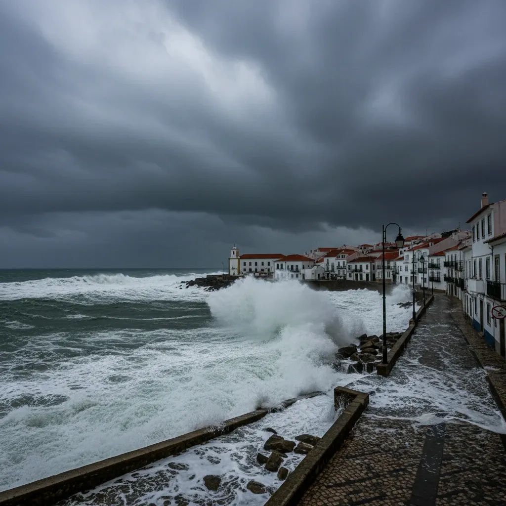
• Heaviest rain since January: Up to 115 mm may fall in less than 24 h over parts of the North and Centre.
• Peak impact Monday 8 Feb, 04:00-12:00: Expect gusts above 90 km/h, coastal waves topping 7 m, and localized power cuts.
• State of calamity extended: The Government has prolonged emergency rules until 15 Feb; insurance claims from previous storms already exceed €210 M.
• Flood-prone districts on alert: Porto, Aveiro, Leiria and Lisbon told to brace for another surge on the Douro, Mondego and Tejo basins.
How the Storm Will Unfold
Meteorologists have nicknamed the low-pressure core “Marta.” The system will first brush the Algarve around 17:00 Sunday, then track north-east overnight. Tight isobars around the centre indicate a steep pressure gradient, meaning strong west-south-west winds will funnel Atlantic moisture straight onto the mainland. Radar models suggest bands of intense rain will arrive in waves—short breaks followed by cloudbursts capable of dropping 15 mm in a single hour.
Unlike the quick-hitting fronts earlier this winter, Marta carries a stalled secondary trough. That feature is expected to sit over the Iberian Peninsula through Tuesday, prolonging showers and keeping river catchments under stress.
What This Means for Residents
Sunday evening is the last realistic window to run essential errands. After that, authorities urge people to stay off secondary roads, many of which are still littered with debris from storms Kristin and Leonardo.
Households in low-lying quarters of Porto, Coimbra, Santarém and Setúbal should:
Clear gutters and basement drains tonight—urban floods last week were aggravated by clogged grates.
Secure loose items on balconies; scaffolding collapses have already injured three workers this month.
Keep an emergency kit—torch, battery pack, bottled water—sufficient for 72 h. E-road charging networks routinely trip when substations flood.
Follow push alerts from ANEPC; the civil-protection app now pushes geo-targeted evacuation orders.
Why the Ground Is Already Primed for Trouble
Soils across mainland Portugal are near saturation after two previous named depressions dumped the equivalent of a February-average rainfall in just eight days. hydrologists at the University of Minho note that runoff coefficients in the Lima, Cávado and Douro basins are above 0.9, meaning “almost every drop will head straight to the river.”
Reservoir managers have begun pre-emptive releases. While that eases pressure on dams, it raises downstream flow rates. Commuters using the A1 and Linha do Norte rail corridor should watch for speed reductions or temporary closures where embankments stand close to swollen channels.
Are Winter Storms Getting Worse?
Most Portuguese climate scientists say yes—but with nuance. Pedro Garrett, a climatologist at NOVA University, points to a 30 % jump in the frequency of explosive cyclogenesis events near the western Iberian margin since 2000. Warmer ocean temperatures enhance evaporation, feeding deeper lows such as Marta.
However, José Manuel Castanheira at the University of Aveiro reminds that memory is short: the country endured comparable sequences in 2010 and 2013. What has changed, he argues, is the amount of critical infrastructure now sitting in reclaimed flood plains, amplifying the impact.
Government & Insurance Angle
The Portugal Cabinet kept the country under a state of calamity until mid-February, unlocking fast-track repairs and allowing mayors to requisition private machinery for debris clearance. Insurers have fielded 39 000 claims since mid-January—double the usual winter tally. Unless Marta fizzles, the industry’s catastrophe fund may reach its retention limit, potentially nudging premiums higher when policies renew in March.
Outlook Beyond Monday
IPMA’s ensemble models show sporadic showers clinging to the mainland through Thursday, then a weak ridge that could finally give Portugal a full dry weekend—its first since December. Until that forecast firms up, civil-protection chiefs say the watchword remains simple: “prepare for more water than you think.”