
A dawn lull in the winds has finally given many Portuguese a breather after two nights of relentless gusts. Storm Kristin is sliding east into Spain, yet strong westerlies continue to lash the Algarve and the Beira interior, keeping civil-protection teams on standby. While electricity crews rush to reconnect hundreds of thousands of homes, meteorologists warn that another pulse of rain and high surf is forming in the Atlantic and could complicate weekend travel.
The morning after – what you need to know now
• Southern districts can still see gusts up to 130 km/h until early afternoon
• Rail traffic between Lisbon and Porto remains reduced; expect longer commutes
• Nearly 340 000 customers were still without power overnight, especially in Leiria and Santarém
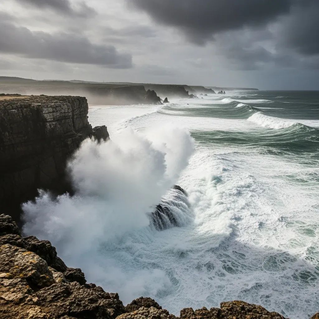
• Coastal waves on the Norte shore may top 8 m late this evening — heed harbour authority warnings
Winds ease, but the south stays braced
In Lisbon the first commuter trains rolled out cautiously, signalling that the capital is edging back to routine. Yet in Faro, Sagres and the uplands of Monchique, orange alerts persist while a “very strong westerly core” keeps pushing 100 km/h gusts inland. IPMA forecaster Patrícia Marques told reporters the stream should weaken “within the next few hours,” but advised motorists crossing the A22 and IC1 to watch for debris. Firefighters in Silves and Tavira, already stretched by fallen pines, have doubled patrols along tourist routes to pre-empt new blockages.
Record books revised in real time
Every tempest invites comparison, and Kristin has etched its name sharply. Monte Real Air Base clocked 178 km/h, nudging past the 176.4 km/h set by Hurricane Leslie in 2018. An even more dramatic 208.8 km/h reading at the Degracias wind farm in Soure awaits IPMA validation but, if confirmed, would be Portugal’s highest land-based measurement. These numbers underscore how the polar-jet perturbations driving Atlantic “bomb cyclones” now regularly deliver hurricane-force events to Iberia, a trend climate scientists have tracked for the past decade.
Where the lights are still out and the roads still closed
E-REDES teams have restored two-thirds of disrupted circuits, yet Leiria woke up with roughly 260 000 meters still dark. In Santarém and Coimbra, sub-stations damaged by toppled eucalyptus remain cut off, complicating hospital logistics. On the road network the biggest headache is the partial closure of the A1 near Pombal, where hundreds of trees fell in domino fashion. National routes EN9, EN246-1 and EN365 likewise demand detours. Drivers venturing toward the Serra da Estrela plateau will find multiple sections snow-covered, a reminder that Kristin’s tail feeds colder air into the highlands.
How Kristin stacks up against Portugal’s storm hall of fame
Meteorologists already rank Kristin alongside Leslie (2018) and Klaus (2009) for sheer wind intensity, though rainfall totals remain lower. Unlike the 1941 cyclone, which cost more than 100 lives, early alerts and mobile-phone push notifications allowed most residents to shelter or postpone travel. Still, the death toll has climbed to at least six nationwide, including three in the municipality of Leiria and one each in Vila Franca de Xira and Silves. Civil-protection officials stress that fallen trees, not flooding, caused most casualties — a detail that may shape future preventive trimming policies.
The next 72 hours: rain bands, heavy surf, cooler nights
IPMA’s short-range models hint at a pause in wind intensity this afternoon before the arrival of a secondary front Saturday. Expect intermittent showers, locally heavy north of the Douro, and a 2-3 °C drop in overnight lows. The western coastline from Viana do Castelo to Peniche enters a red-flag sea-state tonight, with north-westerly swells cresting near 8 m. Coastal authorities are ordering small craft to remain in port and advising curious on-lookers to keep a safe 200 m distance from breaking waves.
Government relief and what residents can do
The Council of Ministers has already activated a calamity declaration for 60 municipalities, unlocking fast-track funds to rebuild roofs, repair municipal roads and subsidise families who lost vehicles or harvests. Insurance inspectors, escorted by local parishes, start door-to-door assessments today. Residents still facing outages should:
Report new damages via the Proteção Civil hotline (808 24 24 24) to ensure mapping of priority zones.
Keep portable generators outside enclosed spaces to avoid carbon-monoxide poisoning.
Photograph property losses before clearing debris, a requirement for both public relief and private insurance.
Building a storm-ready Portugal
Climate-risk researchers at the University of Lisbon note that the frequency of winter storms carrying “sting-jet” signatures has doubled since 2015. They advocate for stricter construction codes in coastal districts, underground cabling in wind-exposed corridors and a national early-warning system capable of push alerts in multiple languages for tourists. Municipalities such as Tomar already plan to upgrade riverbank sensors and promote bairros-resilientes workshops so neighbours can rehearse blackout protocols. As the clean-up from Kristin proceeds, policymakers face a familiar dilemma: invest heavily now or pay a higher price when the next Atlantic low barrels across the Azores High.


